Home
Mobile Menu
Skip to main content
  • About
  • Data
  • Collaborate
  • Learn

Socioeconomic Data and Applications Center (SEDAC)

  1. Earth Observing System Data and Information System (EOSDIS)
  2. EOSDIS Distributed Active Archive Centers (DAACs)
  3. Socioeconomic Data and Applications Center (SEDAC)
Share on Twitter Share on Facebook Share on Pinterest

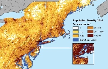
This map shows the storm surge from Hurricane Sandy in October 2012, as estimated by the Federal Emergency Management Agency, coupled with SEDAC population density data for 2010.

NASA's Socioeconomic Data and Applications Center (SEDAC) is operated by the Center for International Earth Science Information Network (CIESIN), a unit of the Earth Institute at Columbia University based at the Lamont-Doherty Earth Observatory in Palisades, New York.

SEDAC’s missions are to synthesize Earth science and socioeconomic data and information in ways useful to a wide range of decision makers and other applied users, and to provide an “Information Gateway” between the socioeconomic and Earth science data and information domains.

SEDAC datasets can be accessed via the dataset section of the SEDAC web site.

Contact Information

Dr. Robert Chen, CIESIN Director, DAAC Manager
Dr. Alex de Sherbinin, Deputy DAAC Manager
Dr. Susana Adamo, Lead Project Scientist
Sri Vinay, DAAC Systems Engineer
Joe Schumacher, User Services Manager

CIESIN, Columbia University
PO Box 1000
61 Route 9W
Palisades, NY 10964

Twitter logoFacebook logoYouTube logoFlickr Logo

Discover

sedac3Get Data

sedac6Learn About Data

sedac1 0 View Map Gallery

sedac5 Explore Data Tools

Visit the DAAC: http://sedac.ciesin.columbia.edu

Learn more about other DAACs

Socioeconomic Data

SEDAC has extensive holdings related to population, sustainability, and geospatial data, and provides access to a large number of multilateral environmental agreements. SEDAC efforts include:

  • Human population distribution on a latitude-longitude grid (U.S. and global)
  • Human settlements and infrastructure, including roads, reservoirs, and dams
  • Ecosystem, agriculture, and wetlands data
  • Intergovernmental Panel on Climate Change (IPCC) socioeconomic scenarios
  • Environmental treaty status and texts
  • Environmental sustainability indicators
  • Global data on natural hazards, poverty, and air and water pollution
  • Map gallery and online mapping and query tools for key datasets

DAAC fact sheet:

SEDAC one pager

Links

  • icon - human dimension
    Environmental Sustainability

  • icon - human dimension
    Geospatial Data

  • icon - human dimension
    Human Interactions

  • icon - human dimension
    Land Use

  • YouTube logo
    Webinar: Discover NASA's Gridded Population of the World

    The Gridded Population of the World (GPW) is a global, high-resolution population data collection. The webinar will cover the history for the product, but will focus primarily on newly developed data - GPW version 4 (GPWv4).

  • YouTube logo
    Webinar: Explore NASA Socioeconomic Data using Web Mapping Services

    This webinar will provide an overview of the geospatial data holdings and data access tools, and highlight ways this socioeconomic data can be integrated with remote sensing data to address problems such as: climate change and potential impacts on migration; health risks of air pollution; forecasting urban expansion and the impacts of that expansion on biodiversity and carbon pools.

  • YouTube logo
    Webinar: Rapid Assessment of Hazard Impacts - NASA SEDAC Hazard Mapper

    Learn about the new NASA SEDAC Hazard Mapper and how to make a rapid assessment of potential hazard impacts.

  • YouTube logo
    Webinar: Remote Sensing Derived Environmental Indicators for Decision Making

    During this webinar we discuss remotely sensed environmental indicator data sets that can enable environmental decision making. We focus on three major issue areas: ambient air pollution, coastal eutrophication and biomass burning.

Page Last Updated: Aug 31, 2021 at 6:38 PM EDT

NASA Earthdata Reference Sheets

  • Atmosphere data set reference sheet
  • Cryosphere data set reference sheet
  • Human Dimensions data set reference sheet
  • Land data set reference sheet
  • Ocean data set reference sheet

Discover Data and Services

  • Earthdata Search
  • International Directory Network (IDN)
  • Data Tools

@NASAEarthdata

Loading Tweets by NASAEarthdata...

We're sorry. Our Twitter feed cannot load right now.

In the meantime, visit us below!

@NASAEarthdata

ABOUT

DATA

COLLABORATE

LEARN

USER RESOURCES

SUPPORT

NASA Links

  • NASA Official: Stephen Berrick
  • Web Privacy Policy
  • Data and Information Policy
  • Communications Policy
  • Freedom of Information Act
  • USA.gov
  • Sitemap