GHRC DAAC
NASA's Global Hydrometeorology Resource Center Distributed Active Archive Center (GHRC DAAC) published beta versions of the Lightning Imaging Sensor on the International Space Station - LIS (ISS), non-quality-controlled standard products on September 17. These data are made available to users until a manual quality control process is complete, at which time they will be replaced by the archive version of the products.
- Beta Non-Quality Controlled LIS (ISS) Science Data
- Beta Non-Quality Controlled LIS (ISS) Backgrounds
These data are collected by the LIS (ISS) used to detect the distribution and variability of total lightning occurring in the Earth’s tropical and subtropical regions. These data can be used for severe storm detection and analysis, as well as for lightning-atmosphere interaction studies. The LIS instrument makes measurements during both day and night with high detection efficiency. The data are available in both Hierarchical Data Format (HDF)-4 and netCDF-4 formats. Data is available from 3/1/2017 forward.
GHRC DAAC published the Global Precipitation Measurement Ground Validation (GPM-GV) NASA S-Band Dual Polarimetric (NPOL) Doppler Radar Olympic Mountains Experiment (OLYMPEX) dataset. The dataset consists data and images from the NPOL radar during the GPM OLYMPEX campaign. NPOL, developed by a research team from NASA's Wallops Flight Facility, is a fully transportable and self-contained S-band (10 cm), scanning dual-polarimetric Doppler research radar that was placed near the ocean on the Olympic Peninsula, Washington. Data files are available from November 5, 2015 thru January 15, 2016 in Universal Format (UF), with browse imagery files in PNG format containing corrected radar reflectivity, differential reflectivity, specific differential phase, differential phase, co-polar correlation, and Doppler velocity images
GHRC DAAC published the GPM-GV Self-Calibrating Multivariate Precipitation Retrieval (SCaMPR) Integrated Precipitation and Hydrology Experiment (IPHEx) dataset which consists of rainfall rate measurements derived from GOES IR data using the SCaMPR algorithm. The SCaMPR algorithm is calibrated using satellite microwave rainfall estimates from the Special Sensor Microwave/Imager (SSM/I) and Advanced Microwave Sounding Unit (AMSU). This dataset contains SCaMPR rain estimates for the time period and spatial extent of the IPHEx campaign from April 30, 2015 to June 17, 2015.
GHRC DAAC published the Global Precipitation Measurement Ground Validation (GPM-GV) Advanced Microwave Precipitation Radiometer (AMPR) Olympic Mountains Experiment (OLYMPEX) dataset. AMPR is an airborne passive microwave radiometer from which cloud, precipitation, water vapor, wind speed and wind direction can be obtained using advanced algorithms with the 10.7, 19.35, 37.1, and 85.5 GHz microwave frequency brightness temperatures. The AMPR brightness temperatures were collected during the GPM OLYMPEX field campaign. AMPR data at GHRC DAAC include netCDF format data files of brightness temperature and PNG browse files of Quality Control Flags and Brightness Temperatures.
LP DAAC
NASA's Land Processes DAAC (LP DAAC) is pleased to announce the availability of the Moderate Resolution Imaging Spectroradiometer (MODIS) Version 6 Downward Shortwave Radiation (DSR) and Photosynthetically Active Radiation (PAR) products. DSR and PAR are key variables in a variety of land-surface applications including ecosystem and hydrological modeling. The Level 3, 5 kilometer data products have been produced from 2001 and will continue to be processed to present day over the coming weeks. The DSR and PAR products are derived from combined. The Digital Object Identifier (DOI) for each dataset is given below to provide users with a persistent link to the product information.
- MCD18A1.006—doi:10.5067/MODIS/MCD18A1.006
- MCD18A2.006—doi:10.5067/MODIS/MCD18A2.006
LP DAAC publicly released a new collection of Terra and Aqua Moderate Resolution Imaging Spectroradiometer (MODIS) Version 6 Land Surface Temperature and Emissivity (LST&E) data products on September 21. These products (M*D21's) offer an alternative to the previously released M*D11 LST&E data collection as they differ in algorithm composition and implementation. M*D21 datasets are available at 1 kilometer resolution for 5-minute, daily, and eight-day temporal periods. There is a total of eight products in the collection.
- doi:10.5067/MODIS/MOD21A1D.006
- doi:10.5067/MODIS/MOD21A1N.006
- doi:10.5067/MODIS/MOD21A2.006
- doi:10.5067/MODIS/MYD21.006
- doi:10.5067/MODIS/MYD21A1D.006
- doi:10.5067/MODIS/MYD21A1N.006
- doi:10.5067/MODIS/MYD21A2.006
NSIDC DAAC
NASA's National Snow and Ice Data Center DAAC (NSIDC DAAC) published new data to the NASA IceBridge DMS Level 0 (L0) Raw Imagery dataset for the Summer 2017 Arctic campaign. This dataset contains level zero imagery taken from the Digital Mapping System (DMS) over Antarctica and Greenland.
NSIDC DAAC published new data to the NASA IceBridge DMS L1B Geolocated and Orthorectified Images dataset for the Summer 2017 Arctic campaign. This dataset contains Level-1B imagery taken from the DMS over Greenland and Antarctica.
NSIDC DAAC published new data to the NASA IceBridge DMS L0 Camera Calibration for the Summer 2017 Arctic campaign. This dataset contains camera calibration reports for IceBridge DMS missions flown over Antarctica and Greenland.
NSIDC DAAC has published data from the Special Sensor Microwave Imager/Sounder (SSMIS) F15 sensor to Making Earth System data records for Use in Research Environments (MEaSUREs) Calibrated Enhanced-Resolution Passive Microwave Daily Equal-Area Scalable Earth (EASE)-Grid 2.0 Brightness Temperature Earth Science Data Record (ESDR) dataset as version 1.2. The minor change in this version corrects the handling of QC flags to retain more data, eliminating only the flagged data in a given channel and taking care not to eliminate data in other channels. This dataset is part of the MEaSUREs Program.
NSIDC DAAC has published the dataset NASA IceBridge BedMachine Greenland, Version 3. Version 3 includes ocean bathymetry all around Greenland based on data from the Ocean Melting Greenland (OMG) and other campaigns of bathymetry measurements. The subglacial bed topography has also been updated by including more ice thickness data and constraining the ice thickness at the ice/ocean interface based on bathymetry data when available.
NSIDC DAAC would like to announce a change to data access for the MEaSUREs Multi-year Greenland Ice Sheet Velocity Mosaic, Version 1 dataset. Data access is now solely available through our primary archive at: https://n5eil01u.ecs.nsidc.org/MEASURES/NSIDC-0670.001/. File level spatial and temporal metadata have been added to aid in searching and ordering the data through Earthdata Search.
NSIDC DAAC has published Scanning Multichannel Microwave Radiometer (SMMR) data to the dataset MEaSUREs Calibrated Enhanced-Resolution Passive Microwave Daily Equal-Area Scalable Earth (EASE)-Grid 2.0 Brightness Temperature Earth Science Data Record (ESDR), Version 1. Also, the Special Sensor Microwave Imager/Sounder (SSMIS) F10 data from this dataset is now available at version 1.2. The minor change in this version corrects the handling of QC flags to retain more data, eliminating only the flagged data in a given channel and taking care not to eliminate data in other channels. This dataset is part of the MEaSUREs Program.
NSIDC DAAC has published new data for August 2017 to the dataset MEaSUREs Greenland Image Mosaics from Sentinel-1A and 1B, Version 2 . The mosaics are derived from C-band SAR (C-SAR) acquired by the Copernicus Sentinel-1A and -1B imaging satellites between January 2015 and August 2017.
This dataset is part of the MEaSUREs Program.
NSIDC DAAC has published version 1.2 of the dataset Making Earth System Data Records for Use in Research Environments (MEaSUREs) Annual Greenland Outlet Glacier Terminus Positions from SAR Mosaics. For this minor version, glaciers were added to two winters: 2006/2007 — glaciers IDs 90 and 91 2008/2009 — glaciers IDs 1-9, 90, and 91.
ORNL DAAC
NASA's Oak Ridge National Laboratory DAAC (ORNL DAAC) published the Carbon Arctic Reservoir Vulnerability Experiment (CARVE) dataset Daily Thaw State of Boreal and Arctic Alaska from the Advanced Microwave Scanning Radiometer (AMSR-E) and the Special Sensor Microwave Imager (SSM/I), 2003-2014. This dataset provides daily 10 km resolution maps of the Alaskan and Arctic Boreal land surface state as either frozen, melting, or thawed. These data are generated from passive microwave radiometer observations made from 2003 through 2014.
ORNL DAAC published the dataset CARVE: In-flight Videos from the CARVE Aircraft, Alaska, 2012-2015. This dataset contains videos captured by a camera mounted on the CARVE aircraft during airborne campaigns over the Alaskan and Canadian Arctic. Flight campaigns took place from 2012 to 2015 between the months of March and November to enable investigation of both seasonal and inter-annual variability in atmospheric gas content.
ORNL DAAC published the CARVE: Daily Flight Reports, 2012-2015. This dataset includes detailed daily flight reports from each of the airborne campaigns over the Alaskan and Canadian Arctic for CARVE. The reports include plots of the flight path, altitude, wind and weather conditions, IR and visible light images, and initial analysis of the atmospheric gas concentrations encountered along the flight. Flight campaigns took place from 2012 to 2015 between the months of March and November to enable investigation of both seasonal and inter-annual variability in atmospheric gas content.
ORNL DAAC published the CARVE In-flight Photos from the CARVE Aircraft, Alaska, 2013-2015. This dataset contains photos taken by scientists aboard the CARVE aircraft during airborne campaigns over the Alaskan and Canadian Arctic. Flight campaigns took place from 2012 to 2015 between the months of March and November to enable investigation of both seasonal and inter-annual variability in atmospheric gas content.
ORNL DAAC published the ABoVE dataset Cumulative Annual Burned Area, Circumpolar High Northern Latitudes, 2001-2015. This dataset provides annual cumulative end-of-season burned area in circumpolar high northern latitudes (HNL) above 60 degrees for the years 2001-2015. The data were generated using the Arctic Boreal Burned Area (ABBA) product (a MODIS-based algorithm). The product is delivered in two spatial domains: circumpolar and a North American subset for areas above 60 degree north.
ORNL DAAC published a revised the Boreal Ecosystem-Atmosphere Study (BOREAS) dataset BOREAS TE-13 Biometry Reports. BOREAS Terrestrial Ecology (TE)-13 team collected data on site characteristics, soil profiles, woody debris, overstory vegetation, and understory vegetation from approximately 100 sites in the Southern Study Area (SSA), Northern Study Area (NSA), and Transect Areas in the boreal forest. This dataset provides 3 reports published by the Canadian Forest Service for the BOREAS project in pdf file format.
ORNL DAAC published the following dataset in its Spatial Data Access Tool (SDAT):
- North American Carbon Program (NACP) Peatland Land Cover Map of Upper Peninsula, Michigan, 2007-2011 (see https://webmap.ornl.gov/ogc/dataset.jsp?ds_id=1513).
- Carbon Monitoring System (CMS): Tree-level Aboveground Biomass and Uncertainty for California Forests, 2005-2014 (see https://webmap.ornl.gov/ogc/dataset.jsp?ds_id=1537).
- CMS: LIDAR-derived Canopy and Elevation for Sites in Kalimantan, Indonesia, 2014 (see https://webmap.ornl.gov/ogc/dataset.jsp?ds_id=1540).
PO.DAAC
NASA's Physical Oceanography DAAC (PO.DAAC) announced the release of the version 2.41 Visible Infrared Imaging Radiometer Suite (VIIRS) - National Polar-orbiting Operational Environmental Satellite System (NPOESS) Preparatory Project (NPP) Level-2P/3U Sea Surface Temperature (SST) datasets produced by the NOAA Office of Satellite and Product Operations (OSPO). See: https://podaac.jpl.nasa.gov/announcements/2017-10-09_NOAA_OSPO_VIIRS_L2P_L3U_GHRSST_upgraded_v2.41
PO.DAAC successfully ingested seven years of data for a new Quick Scatterometer (QuikSCAT) Level 1C Averaged Sigma-0 and Winds product from the Non-Spinning Antenna Version 2.0 dataset.
SEDAC
NASA's Socioeconomic Data and Applications Center (SEDAC) datasets, Global Population Count Grid Time Series Estimates, v1 (1970-2000) and Global Population Density Grid Time Series Estimates, v1 (1970-2000), were released on 13 October as part of the SEDAC Population Dynamics data collection. These datasets represent a “back-cast” time series of population count and density on a 30-arc-second (~1 km) grid over a 30-year period, using as a baseline the year 2000 population grid from SEDAC's Global Rural-Urban Mapping Project, Version 1 (GRUMPv1) dataset. Subnational population growth rates were adapted from the History Database of the Global Environment (HYDE) database, and population grids were adjusted so that country population totals equal the UN World Population Prospects (2008 Revision) estimates for each country for the years 1970, 1980, 1990, and 2000. These grids were developed as an input to the dataset, Global Estimated Net Migration Grids By Decade, v1 (1970-2000). See: http://sedac.ciesin.columbia.edu/data/set/popdynamics-global-pop-count-time-series-estimates and http://sedac.ciesin.columbia.edu/data/set/popdynamics-global-pop-density-time-series-estimates.
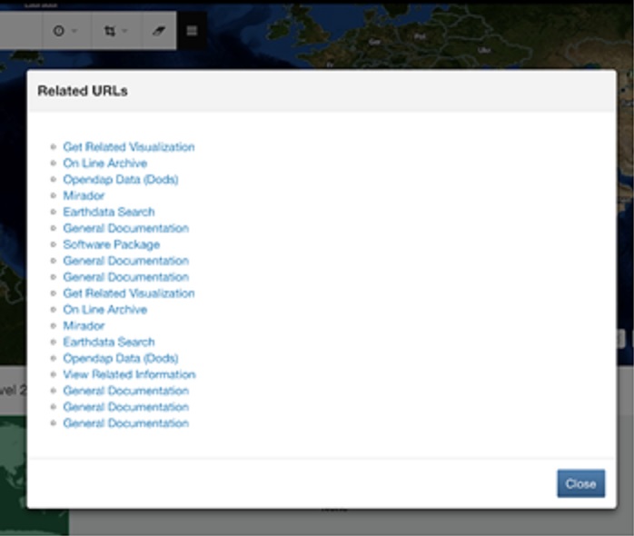
The display of Related URLs has been improved in Earthdata Search. Earthdata Search now displays the full link along with the URL type and subtype (when applicable). Additionally, Related URLs are grouped together by type for easier navigation and understanding of link types. See before/after screenshots below:
Before: