NASA’s Earth Observing System Data and Information System (EOSDIS) provides a wealth of data and products supporting scientific research of the atmosphere, oceans, and land. Data from the Earth Observing System (EOS) instruments aboard the Terra, Aqua, and Aura satellites make global measurements daily. The measurements are processed into higher-level "standard" products within 8-40 hours of observation and then made available to users, primarily Earth science researchers.
However, application users, operational agencies, and even researchers require EOS products to support research and applications, such as numerical weather and climate prediction; forecasting and monitoring natural hazards, ecological/invasive species, agriculture, and air quality; providing help with disaster relief; and homeland security. These users often need data much sooner than routine science processing allows, usually within three hours, and are willing to trade science product quality for timely access. In response to this need, NASA has developed a Land, Atmosphere Near real-time Capability for EO (LANCE).
Origins of LANCE
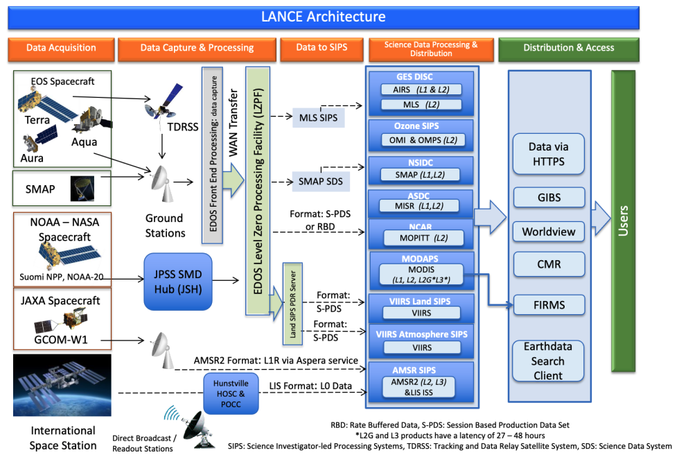
Building on the existing EOSDIS near real-time (NRT) capabilities, NASA’s Earth Science Division sponsored the development of LANCE. LANCE consists of special processing elements, co-located with selected EOSDIS Distributed Active Archive Centers (DAACs) and processing facilities. These elements process expedited data from the Earth Observing System (EOS) Data and Operations System (EDOS) using optimized science algorithms to provide data in near real-time. LANCE development is jointly sponsored by the Flight, Research and Analysis, and Applied Sciences Programs within NASA’s Earth Science Division (ESD).

System Architecture
The LANCE architecture leverages existing near real-time satellite data processing systems that are managed by the Earth Science Data and Information System (ESDIS) Project at NASA's Goddard Space Flight Center.
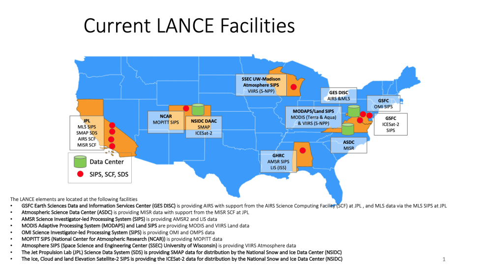
The LANCE elements are located at the following facilities:
- Advanced Microwave Scanning Radiometer Science Investigator-led Processing System (AMSR SIPS) providing AMSR2 data and Lightning Information System (LIS) on the International Space Station (ISS)
- Atmospheric Science Data Center (ASDC) providing Multi-angle Imaging SpectroRadiometer (MISR) data with support from the MISR Science Computing Facility at NASA's Jet Propulsion Laboratory (JPL)
- Goddard Earth Sciences Data and Information Services Center (GES DISC) providing Atmospheric Infrared Sounder (AIRS), and Microwave Limb Sounder (MLS) data via the MLS SIPS at JPL
- Moderate Resolution Imaging Spectroradiometer (MODIS) Adaptive Processing System (MODAPS) providing MODIS and Visible Infrared Imaging Radiometer Suite (VIIRS) data
- Measurement of Pollution in the Troposphere SIPS (MOPITT SIPS) providing MOPITT data via the National Center for Atmospheric Research
- Ozone Monitoring Instrument SIPS (OMI SIPS) providing OMI data
- Suomi National Polar-orbiting Partnership (Suomi NPP) Ozone Mapping Profiler Suite (OMPS SIPS) providing OMPS data
- Suomi NPP Land SIPS providing VIIRS Land data
- Suomi NPP Atmosphere SIPS providing VIIRS Atmosphere data
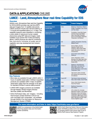
Near real-time data are currently available for the following instruments:
- Atmospheric Infrared Sounder (AIRS)
- Advanced Microwave Scanning Radiometer 2 (AMSR2)
- Lightning Imaging Sensor on the International Space Station (LIS ISS)
- Advanced Topographic Altimeter System (ATLAS) on the Ice, Cloud, and land Elevation Satellite-2 (ICESat-2)*
- Multi-angle Imaging Spectroradiometer (MISR)
- Microwave Limb Sounder (MLS)
- Moderate Resolution Imaging Spectroradiometer (MODIS)
- Measurement of Pollution in the Troposphere (MOPITT)
- Ozone Monitoring Instrument (OMI)
- Ozone Mapping Profiler Suite (OMPS)
- Soil Moisture Active Passive (SMAP)
- Visible Infrared Imaging Radiometer Suite (VIIRS)
*Data from ICESat-2 are expedited and made available within 3 days of satellite observation rather than the average 45 days for the standard data.
These elements are supplied with rate-buffered data and/or session-based production datasets from the EDOS as soon as they are downlinked from satellites or transmitted from ground stations, generally within 30 minutes to two hours after observation. Each element then processes raw data into higher-level products before they are made available to users. A key NASA tenet, that of product validation and documentation by science instrument team members is being applied here as well as to the standard products, to ensure that user feedback and evolving user needs will translate into appropriate product modifications and new products.
Building on a significant investment by NASA in developing algorithms and products, LANCE provides a range of products that have demonstrated utility for applications requiring near real-time data. From lower level data products such as calibrated geolocated radiances to higher-level products such as sea ice extent, snow cover, and cloud cover, users have integrated LANCE data into forecast models and decision support systems.

