From estimates of afforestation and deforestation to assessments of greenness and land cover type, the images we get from NASA’s polar-orbiting and geostationary satellites can tell us a lot about what’s happening on the Earth’s terrestrial surfaces. Unfortunately, this two-dimensional imagery does not provide much information about the structure of the plants growing on those terrestrial surfaces. Until now, data offering that richer, three-dimensional assessment of the Earth’s terrestrial biomes have been scattered and in short supply. Thanks to the Global Ecosystem Dynamics Investigation (GEDI) mission, which produces high resolution laser-ranging observations of the 3D structure of the Earth, this is beginning to change.

Launched on December 5, 2018 and installed on the International Space Station (ISS)’s Japanese Experiment Module (JEM)-Exposed Facility, GEDI is a full waveform lidar (i.e., laser version of radar) instrument offering the highest resolution and densest sampling of any lidar ever put in orbit. Led by scientists at the University of Maryland, the mission is supported by NASA’s Goddard Space Flight Center, located in Greenbelt, Maryland. Its data are transferred to the GEDI Mission Operations Center and then processed through the Science Operations Center, both of which are located at Goddard, and then sent to two of NASA's Earth Observing System Data and Information System (EOSDIS) Distributed Active Archive Centers (DAACs) where they are archived, managed, and distributed to a diverse worldwide user community.
The first, lower-level datasets released from the GEDI mission — Level 1 and Level 2 data — were made available in January 2020 through NASA’s Land Processes DAAC (LP DAAC), a partnership between NASA and the US Geological Survey that manages, archives, and distributes EOSDIS land processes data, services, and tools for discovering and analyzing data. Now, the GEDI Level 3 data product — GEDI L3 Gridded Land Surface Metrics, Version 1 — is available from NASA’s Oak Ridge National Laboratory DAAC (ORNL DAAC), a partnership between NASA and the U.S. Department of Energy that is responsible for EOSDIS data related to biogeochemical dynamics, ecological data, and environmental processes.
All EOSDIS data products are processed at levels ranging from 0 to 4. Level 0 products are raw data at full instrument resolution. Level 1 data are reconstructed, unprocessed instrument data at full resolution and time-referenced and annotated with ancillary information, such as georeferencing parameters. Level 2 data provide derived geophysical variables at the same resolution and location as Level 1 source data. Level 3 data contain variables mapped on uniform space-time grid scales, usually with some completeness and consistency, and Level 4 data are model outputs or results from analyses of lower-level data (e.g., variables derived from multiple measurements). All Earth Observing System (EOS) instruments must have Level 1 products. Most have products at Levels 2 and 3, and many have products at Level 4, including GEDI.
To obtain its measurements of the Earth’s terrestrial ecosystems, GEDI relies on a lidar (short for “light detection and ranging”) system that emits laser beam pulses and records the reflected energy from plant stems, branches, and leaves, as well as the terrain. This reflected energy, known as a waveform, is the sole observable from the GEDI mission and the source of all GEDI data products. The waveforms quantify the vertical distribution of vegetation and, when paired with data from its Global Positioning System (GPS) and Inertial Measurement Unit (IMU) receiver, are used to create very accurate, geolocated 3D measurements of the planet’s terrestrial landscapes.

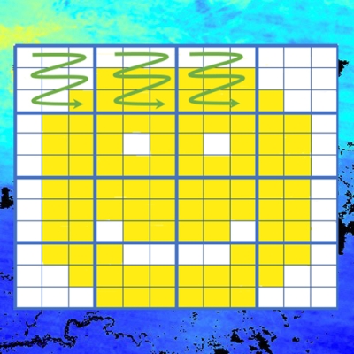
As shown in the graphic above, the GEDI instrument obtains 3D measurements of the Earth’s surface using three lasers that produce 8 parallel tracks of observations. Each laser fires 242 times per second and illuminates a 25-meter footprint on the surface within which four surface parameters — surface topography, canopy height metrics, canopy cover metrics, and vertical structure metrics—are calculated. Each footprint is separated by 60 meters along the track, with between-track spacing of about 600 meters (1,969 feet) and a total width of 4.2 kilometers (about 2.6 miles) across all eight tracks.
GEDI measurements are made over the Earth’s surface between 51.6° North and 51.6° South latitudes in a crisscross pattern, similar to that seen on a ball of yarn (see image of GEDI tracks along the East Coast at right). The GEDI instrument can also be rotated on the JEM by up to six degrees, allowing the lasers to be pointed up to 40 km on either side of the ISS ground track. This capability helps GEDI sample the Earth’s land surface as completely as possible, filling in coverage gaps due to clouds.

As GEDI moves over the Earth, it makes systematic and detailed 3D measurements of forest canopy height, forest structure, and surface elevation of the planet's most diverse terrestrial biomes — measurements that can be used to further the ecological research community’s understanding of Earth’s habitats. Version 1 of this Level 3 dataset provides measurements of global gridded mean canopy height and ground elevation and standard deviation of canopy height and ground elevation. In addition, one of its layers provides the count of good quality laser footprints within each 1 kilometer (km) by 1 km grid cell.
“This initial release of the Level 3 product aggregates data for a period of about one year from April 2019 to April 2020.” said Dr. Rupesh Shrestha, a research staff member at ORNL DAAC. “The number of footprints included in each grid varies depending on available GEDI tracks in that particular grid. Higher counts occur where the ISS orbit tracks overlap, but there are also gaps in between these tracks. In future releases, these gaps will decrease as GEDI records more footprints, and we will have much better coverage of the Earth between the 51.6 North and South latitudes.”
This Level 3 gridded data can be used in studies of carbon and water cycling processes, biodiversity, and habitats, and may be of immense value to climate modeling, forest management, snow and glacier monitoring, and generating digital elevation models. According to Shrestha, future versions of the GEDI Level 3 products will use footprints with improved geolocation accuracy and calibration as well as advanced gridding algorithms to produce the best estimate of the mean and its error for each grid cell.
Beyond managing, archiving and distributing a variety of regional and global biogeochemical and environmental satellite, in situ, model and land validation datasets, ORNL DAAC also provides a variety of data subsetting and visualization tools and services, such as the Spatial Data Access Tool (SDAT) Web-based tool that enables users to browse, visualize, and download geospatial data in various user-selected spatial/temporal extents, formats, and projections.
“Our role is to make the data accessible to researchers by providing a range of standards-based interoperable tools and services such as SDAT,” said Shrestha. “SDAT provides Open Geospatial Consortium (OGC) services that will help users visualize and bring GEDI data into GIS applications for further analysis.”
The GEDI Level 3 data is also available in ORNL DAAC’s Fixed Sites Subset Tool and Global Subsets Tool for locations within the GEDI spatial coverage. The Fixed Sites Subset Tool provides pre-computed 8 km x 8 km subsets and time series visualizations for 29 different NASA earth data products at over 3100 different research sites around the world. The Global Subsets Tool allows users to select a location and get subsets and time series visualizations covering up to 200 km x 200 km for the selected NASA data products. The Global Subsets Tool also has Web Service interface that provides access to this capability from within scripts and other computer programs.
Level 4 GEDI data products, the highest-level data products from the GEDI mission, will offer model outputs, and be available later this calendar year. These products will provide footprint metrics derived from the Level 1 and 2 data products (i.e., ground and vegetation metrics to produce footprint estimates of aboveground biomass density).
“The Level 3 product is a gridded version of Level 2 footprints. The Level 4 products will be based on models that estimate biomass,” Shrestha said. “Level 4A products will use the waveform height metrics from the Level 2 footprints and field-based information to estimate above ground biomass density for each footprint-print. Level 4B will provide gridded estimates of those above-ground biomass estimates. This is the first time this kind of information will be available at this level of detail for tropical and temperate forests across the world.”
Traditionally, studies of Earth’s terrestrial ecosystems have relied on limited field studies and sampling from airborne lidar. Now, with its global gridded measurements of mean canopy height and ground elevation and standard deviation of canopy height and ground elevation, the Level 3 GEDI data available from the ORNL DAAC will fill significant data gaps about the planet’s terrestrial biomes and inform ecological research for decades to come.
To learn more about the GEDI mission and GEDI data products, see the following online resources:
GEDI mission website
GEDI data can be searched for and discovered using the EOSDIS Earthdata Search application.
LP DAAC GEDI Landing Pages:
- Level 1B (doi.org/10.5067/GEDI/GEDI01_B.002)
- Level 2A (doi.org/10.5067/GEDI/GEDI02_A.002)
- Level 2B (doi.org/10.5067/GEDI/GEDI02_B.002)
ORNL DAAC GEDI Landing Page:
- Level 3 (doi.org/10.3334/ORNLDAAC/1865)
- Level 4 data (expected in calendar year 2021)