Agriculture uses more land on Earth than any other human activity. Which is why mapping agricultural extent and farming activities is important to many different fields of research.
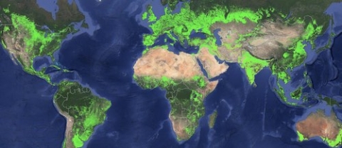
The Global Food Security-support Analysis Data (GFSAD) collection provides detailed maps of agricultural croplands around the world at a 30-meter resolution. This dataset improves upon previously published maps by using high-resolution remote sensing data acquired from multiple satellite instruments.
The development of the dataset was led by Dr. Prasad Thenkabail, research geographer at the USGS, with the help of funding from NASA's Making Earth System Data Records for Use in Research Environments (MEaSUREs) Program. MEaSUREs is a competitive program through NASA's Earth Science Data Systems (ESDS) Program that supports projects focused on the generation of new data products that meet the needs of the Earth science community.
According to GFSAD estimates, there were 1.873 billion hectares of net agricultural cropland around the world in 2015, which is about 15% of Earth's ice-free land. About 400 million of these hectares are irrigated, according to Thenkabail's analysis.
The GFSAD project is a collaborative effort between the USGS, NASA, Bay Area Environmental Research Institute, University of New Hampshire, California State University Monterey Bay, University of Wisconsin, Northern Arizona University, International Crops Research Institute for the Semi-Arid Tropics, U.S. Department of Agriculture, U.S. Environmental Protection Agency, Indonesian Agency for Agricultural Research and Development, and Google.
"With this dataset you can look at individual farm fields anywhere in the world, which is a huge improvement over previous cropland maps with coarser spatial resolution," said Thenkabail. Earlier efforts to map croplands around the world produced data at a 1-kilometer resolution (1 pixel = 100 hectares) or 250-meter resolution (1 pixel = 6.25 hectares), but GFSAD is at a 30-meter resolution (1 pixel = 0.09 hectares), providing researchers with field-scale data.
Thenkabail and his colleagues used a time-series of Landsat 7 and Landsat 8 imagery and machine learning algorithms to determine the extent of croplands. They performed this analysis using Google Earth Engine, which allowed them to take advantage of cloud computing of petabyte-scale datasets.
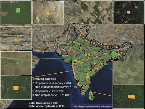
The training data included ground surveys and very high spatial resolution (sub-meter to 5-meter resolution) commercial imagery from numerous satellites such as IKONOS, QuickBird, GeoEye, and WorldView obtained through the National Geospatial Agency.
The research team published the products, user guides, algorithm theoretical basis documents (ATBDs), and the Google Earth Engine code at NASA's Land Processes Distributed Active Archive Center (LP DAAC) so that the research was transparent and reproducible. They also published the training data used in their machine learning algorithms. Having adequate training data is one of the key limitations of advancing machine learning in Earth science, and publishing these data along with the code allows scientists to use these resources to accelerate their research.
Access the GFSAD Collection
The GFSAD collection can be accessed and downloaded using Earthdata Search or the DOI links below.
GFSAD30AFCE: Cropland Extent 2015 Africa 30 m (doi:10.5067/MEaSUREs/GFSAD/GFSAD30AFCE.001)
GFSAD30AUNZCNMOCE: Cropland Extent 2015 Australia, New Zealand, China, Mongolia 30 m (doi:10.5067/MEaSUREs/GFSAD/GFSAD30AUNZCNMOCE.001)
GFSAD30EUCEARUMECE: Cropland Extent 2015 Europe, Central Asia, Russia, Middle East 30 m (doi:10.5067/MEaSUREs/GFSAD/GFSAD30EUCEARUMECE.001)
GFSAD30NACE: Cropland Extent 2015 North America 30 m (doi:10.5067/MEaSUREs/GFSAD/GFSAD30NACE.001)
GFSAD30SAAFGIRCE: Cropland Extent 2015 South Asia, Afghanistan, Iran 30 m (doi:10.5067/MEaSUREs/GFSAD/GFSAD30SAAFGIRCE.001)
GFSAD30SACE: Cropland Extent 2015 South America 30 m (doi:10.5067/MEaSUREs/GFSAD/GFSAD30SACE.001)
GFSAD30SEACE: Cropland Extent 2015 Southeast and Northeast Asia 30 m (doi:10.5067/MEaSUREs/GFSAD/GFSAD30SEACE.001)
GFSAD30VAL: Cropland Extent 2015 Global Validation (doi:10.5067/MEaSUREs/GFSAD/GFSAD30VAL.001)
Learn More
Explore the data and learn more about the research at croplands.org.
Gumma, M.K., Thenkabail, P.S., Teluguntla, P.G., Oliphant, A., Xiong, J., Giri, C., ... & Whitbread, A.M. (2020). Agricultural cropland extent and areas of South Asia derived using Landsat satellite 30-m time-series big-data using random forest machine learning algorithms on the Google Earth Engine cloud. GIScience & Remote Sensing, 57(3): 302-322. doi:10.1080/15481603.2019.1690780
Phalke, A.R., Özdoğan, M., Thenkabail, P.S., Erickson, T., Gorelick, N., Yadav, K. & Congalton, R.G. (2020). Mapping croplands of Europe, Middle East, Russia, and Central Asia using Landsat, Random Forest, and Google Earth Engine. ISPRS Journal of Photogrammetry and Remote Sensing, 167: 104-122. doi:10.1016/j.isprsjprs.2020.06.022
Oliphant, A., Thenkabail, P.S., Teluguntla, P., Xiong, J., Gumma, M.K., Congalton, R. & Yadav, K. (2019). Mapping cropland extent of Southeast and Northeast Asia using multi-year time-series Landsat 30-m data using random forest classifier on the Google Earth Engine Cloud. International Journal of Applied Earth Observation and Geoinformation, 81: 110-124. doi:10.1016/j.jag.2018.11.014
Teluguntla, P., Thenkabail, P.S., Oliphant, A., Xiong, J. & Gumma, M.K. (2018). A 30-m landsat-derived cropland extent product of Australia and China using random forest machine learning algorithm on Google Earth Engine cloud computing platform. ISPRS Journal of Photogrammetry and Remote Sensing, 144: 325-340, ISSN 0924-2716. doi:10.1016/j.isprsjprs.2018.07.017
Thenkabail, P.S., Teluguntla, P., Xiong, J., Oliphant, A., Congalton, R., Ozdogan, M., Gumma, M.K., Tilton, J., Giri, C., Milesi, C., Phalke, A., Massey, M., Yadav, K., Milesi, C., Sankey, T., Zhong, Y., Aneece, Y. & Foley, D. (2017). Global Cropland Extent Product at 30m (GCEP30) derived using Landsat Satellite Time-series Data for the Year 2015 through Multiple Machine Learning Algorithms on Google Earth Engine (GEE) Cloud. NASA Land Processes Distributed Active Archive Center (LP DAAC), https://lpdaac.usgs.gov/news/release-of-gfsad-30-meter-cropland-extent-products/.
Xiong, J., Thenkabail, P.S., Tilton, J.C., Gumma, M.K., Teluguntla, P., Oliphant, A., ... & Gorelick, N. (2017). Nominal 30-m Cropland Extent Map of Continental Africa by Integrating Pixel-Based and Object-Based Algorithms Using Sentinel-2 and Landsat-8 Data on Google Earth Engine. Remote Sensing, 9(10): 1065. doi:10.3390/rs9101065


