Since 2009, the Land, Atmosphere Near real-time Capability for NASA’s Earth Observing System (EOS), or LANCE, has been providing data and data products generally within three hours of a satellite observation. The products, services, and data distribution strategies developed by the LANCE team have helped transform not only how Earth observing data are used, but also the worldwide accessibility of these data. As LANCE enters its second decade, it’s worth looking back at 10 LANCE milestones. While this list is not meant to be all-inclusive, it provides an overview of how this major initiative evolved to provide data from instruments aboard Earth observing satellites rapidly, accurately, and consistently.
1. Development of the NRTPE and Rapid Response, the precursors to LANCE
The evolution of what would become known as LANCE began in 2001 with the development of the NASA/NOAA/Department of Defense Near Real-Time Processing Effort (NRTPE). At the request of the U.S. Forest Service (USFS), NASA’s Earth Science Data and Information System (ESDIS) Project collaborated with the USFS and the University of Maryland Department of Geography to create a system called Rapid Response using the NRTPE feed as a foundation. Rapid Response provided access to near real-time imagery from the Moderate Resolution Imaging Spectroradiometer (MODIS) instrument aboard NASA’s Terra and Aqua Earth observing satellites to support wildfire suppression and response.
2. Establishment of LANCE in 2009
By 2008, a growing demand for near real-time data spurred a NASA Headquarters-led effort to build a new, more robust system to process and distribute near real-time data. In July 2009, the ESDIS Project led the development of a new near real-time system serving data from not only the MODIS instrument, but also the Atmospheric Infrared Sounder (AIRS) aboard NASA’s Aqua satellite, the Microwave Limb Sounder (MLS) and Ozone Monitoring Instrument (OMI) aboard NASA’s Aura satellite, and, soon afterward, the Advanced Microwave Scanning Radiometer for EOS (AMSR-E) aboard Aqua. This new system was formally established by NASA in September 2009 and named “LANCE.”
3. User/Community Feedback Mechanisms Established
In December 2009 the ESDIS Project held a workshop to better understand the needs of LANCE users and to nominate the first members of a new LANCE User Working Group (UWG). This advisory group provides guidance and recommendations concerning topics related to the LANCE system, capabilities, and services and represents the needs of the LANCE applications user communities. The ESDIS Project conducted an informal survey of LANCE users in 2012 to better understand user needs and solicit feedback on improvements to better serve near real-time applications. Formal user surveys were conducted in 2013 and 2016.
4. Rapid Response Integrated with LANCE in 2011
After its establishment in 2001, Rapid Response remained a stand-alone system. Between 2004 and 2011, new MODIS spectral band combinations were implemented to enhance snow/ice, floods, and burn scars. Recognizing the importance of near real-time imagery for users who lived in areas with low internet bandwidth service, the MODIS Rapid Response system was incorporated into LANCE in February 2011. The Rapid Response system was phased out in 2019 and replaced with Worldview Snapshots.
5. The Development of GIBS and NASA Worldview Powered by LANCE (2011)

MODIS Rapid Response demonstrated not only the ability to provide near real-time imagery, but also the value of quick and simple access to this imagery. The next step in LANCE’s development was the creation of a way for data users to easily download near real-time imagery, interactively explore this imagery, and download the underlying data behind this imagery. The results of these efforts were the development of the LANCE-powered Global Imagery Browse Services (GIBS) and the NASA Worldview interactive data visualization application in 2011. GIBS and NASA Worldview were game-changers in the way near real-time imagery were distributed and used, and provided users with quick and easy access to daily, global imagery in near real-time.
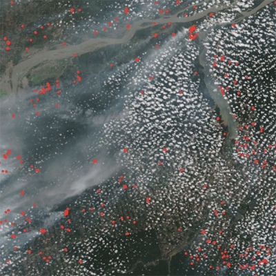
6. Development of FIRMS

The Fire Information for Resource Management System (FIRMS), initially developed at the University of Maryland, was transitioned to LANCE in May 2010, and became formally operational in LANCE in May 2012. FIRMS provides near real-time thermal anomaly data (including an approximate location of a detected hotspot) from the MODIS and Visible Infrared Imaging Radiometer Suite (VIIRS) instruments. Global active fire detections can be viewed interactively using the FIRMS Fire Map application, and FIRMS users can sign up to receive email Fire Alerts notifying them of potential fires detected in specific areas of interest. Through this free service, alerts can be received in near real-time or as daily or weekly summaries. Every week approximately 240,000 FIRMS alerts (including daily alerts, Rapid Alerts, and weekly alerts) are sent to users in more than 160 countries, according to the FIRMS team.
7. Improvements in Near Real-Time Data Latency and Reliability
The overall LANCE objective is to provide near real-time data and imagery generally within three hours of an instrument observation. NASA’s Earth Observing System (EOS) Data and Operations System (EDOS) is the primary provider of all LANCE instrument data directly downloaded from NASA EOS satellites like Terra, Aqua, and Aura. In 2011, EDOS made significant enhancements to the way these data were streamed from ground stations and also improved the way these data were processed and prioritized, which helped reduce the latency for data delivered to LANCE. Today, most LANCE products are available to data users less than three hours after an observation, with some products being available less than two hours after acquisition.
8. First non-EOS mission instrument data added to LANCE in 2015
The addition of Advanced Microwave Scanning Radiometer 2 (AMSR2) data from the Japan Aerospace Exploration Agency Global Change Observation Mission-Water (GCOM-W1) satellite in March 2015 was the first non-EOS mission data added to LANCE. Currently, six unique AMSR2 data products are available through LANCE.
9. Significant growth in data available through LANCE
The addition of AMSR2 near real-time data was followed by the addition of data from several more instruments, including:
- Multi-angle Imaging SpectroRadiometer (MISR) aboard NASA’s Terra satellite; June 2016
- Measurement of Pollution in the Troposphere (MOPITT) aboard Terra; October 2017
- VIIRS aboard the joint NASA/NOAA Suomi National Polar-orbiting Partnership (Suomi NPP) satellite; first of several data products added February 2016
- Ozone Mapping Profiler Suite (OMPS) aboard Suomi NPP; December 2017
- VIIRS aboard the joint NASA/NOAA NOAA-20 satellite; August 2019
Along with new instrument data, new data products are constantly being added to the system. Recent additions include:
- VIIRS Nighttime Imagery product; January 2017
- MODIS Global Near Real-Time Flood Product; approved in April 2017
- OMPS Pyrocumulonimbus product (PyroCb); October 2018
- MODIS Thermal Alert System (MODVOLC); produced in 2019 by LANCE from MODIS data to serve the volcano monitoring community and distributed primarily through the University of Hawaii
- MODIS Multi-Angle Implementation of Atmospheric Correction (MAIAC); produced in 2019 by LANCE to support the air quality and climate/atmospheric modeling communities
10. Addition of first International Space Station mission data in 2018
The Lightning Imaging Sensor (LIS) was installed on the International Space Station in February 2017. LANCE LIS near-real time data are available within two minutes of observation and provide total lightning measurements between +/- 48 degrees latitude, a geographic range that includes nearly all global lightning.