Most days, Fred Denn gets in his car and takes the expressway to work, like regular people. Once or twice a month, he instead boards a helicopter to commute east from Virginia’s Chesapeake Bay to an eighty-foot square lighthouse platform, more than fifteen miles out to sea.
Normally behind desks and computers processing science data, Denn and colleagues Bryan Fabbri and Bob Arduini pull out their to-do lists and get to work checking, repairing, and calibrating an array of scientific instruments that NASA maintains on the U.S. Coast Guard platform. Denn said, “We’re part of a project to measure climate change. Satellites measure the entire Earth and we measure one spot, and compare our measurements to the satellite.” Slowly, they are helping to build a long and detailed record that helps researchers understand how Earth’s atmosphere and clouds work together to retain and reflect thermal energy, making and changing the globe’s climate.

Clouds, clouds, and clouds
Some days, clouds blanket the sky at the site, which is part of the CERES Ocean Validation Experiment (COVE). Those measurement days are important to COVE, because clouds affect the exchange of heat in varied and complex ways. For instance, cloud cover can hold heat in like a blanket at night, or reflect solar energy back to space and keep you cool during the day, depending on the type of cloud. Likewise, the lack of cloud cover on a clear, cool night makes gardeners rush out to cover plants against frost, as heat escapes and the atmosphere cools more intensely than on a cloudy night.
COVE has a small but significant role in the Clouds and the Earth’s Radiant Energy System (CERES), a long-running NASA experiment to study Earth’s atmospheric heat system. CERES integrates a suite of satellite observations to measure how Earth is holding or radiating heat, what scientists call Earth’s energy budget.
Denn said, “You could think of it as a sphere that is outside of the Earth’s atmosphere, that encloses the entire Earth system. We’re measuring the amount of energy coming in and out of that sphere.” If the balance of heat retained or radiated out to space by land, oceans, and atmosphere changes over time, then our planet and its climate will warm or cool.
CERES focuses on how Earth’s energy balance may be changing over the long term, and investigates what roles clouds play. Researchers learned from previous studies that getting the cloud cover right matters when measuring the movement of radiation, or heat, from ground to sky. Ongoing since 1997, CERES followed on an earlier remote sensing study of Earth’s energy balance, the Earth Radiation Budget Experiment (ERBE), which collected data on radiation from 1984 to 2005.
COVE project lead Greg Schuster said, “During ERBE they were trying to figure out if clouds cooled the climate or warmed the climate. You have low clouds that are very bright, so sunlight gets reflected up. Then there are high cirrus clouds that basically block the outgoing longwave radiation, the same way greenhouse gas will block radiation from leaving the planet. You’ve got two different types of clouds with two different effects, and which one dominates? Back then the conclusion was that the low clouds cool the planet slightly.”
But researchers still had many essential questions about clouds and climate, so CERES was specifically designed to detect cloud height, thickness, and amount, along with radiation. “Clouds are one of our major wildcards for studying climate,” Schuster said. “What happens if climate warms up? More water evaporates, and makes more clouds. Does it make high clouds, or low clouds?” This raises a scenario for systems feedback: a warming climate could produce high clouds that accelerate warming even more, or low clouds that cool the planet.

Ocean and atmosphere
The small COVE site helps align the view from the sky with reality on the ground. On a clear day, the COVE team may be able to look up from their man-made deserted island through the upper atmosphere, and see the sun brightly shining overhead. At the same time, satellites orbiting the Earth look down on the lighthouse. Denn said, “When the satellite looks at the lighthouse site, it sees only water.” The seeming invisibility of the lighthouse platform to satellites is precisely why the instruments were placed here: this small square is the closest thing to placing instruments on the ocean surface.
Comparing ocean surface readings with satellite measurements helps to validate the global data. Denn said, “We are data collectors, trying to assess whether or not data actually represent what we are trying to measure.” Oceans cover 71 percent of Earth’s surface, so accurate measurements over the oceans are a large part of the energy equation. The ocean, however, does not afford many solid surfaces for placing instruments.
Schuster said, “The advantage of the COVE site is that the surface is surrounded by water. In contrast, island sites can have their own local weather. The island will heat up, so clouds will form over the island, and the instruments on the island will look up and see a cloudy day. The satellite will look down at the island and see a tiny speck with a few clouds, and call it a clear day, so it’s a mismatch.”
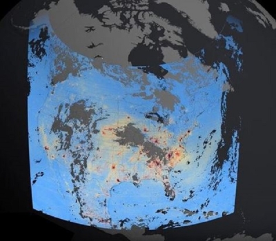
Overhead, CERES atmospheric instruments fly in pairs on the NASA Terra and Aqua satellites, with each instrument collecting data on radiation, aerosols, and other atmospheric properties. On the same satellites, imaging instruments such as the Moderate Resolution Imaging Spectroradiometer (MODIS) provide cloud properties by sensing their unique wavelengths. Computer models then gather all these data into a complete profile of the atmosphere’s radiative properties and cloud cover for the entire globe. The CERES data are available to researchers via NASA's Atmospheric Science Data Center (ASDC).

Schuster said, “We’ve got satellites that measure the energy budget at the top of the atmosphere, and then ways to infer the energy budget at the surface, so we can capture the radiative properties of entire columns of the atmosphere as the satellites pass over the Earth. The COVE data indicate that we’re doing a better job of computing what is at the surface than at other locations.”
A long time series
While only a single validation site, COVE plays an important role in the accuracy of these global satellite measurements. Fabbri said, “There’s no other validation site like this in the world; to our knowledge, it’s the only true water site. When modeling flux from the top of the atmosphere to the surface, COVE data model the best.”
So the COVE team maintains its regular flights to the lighthouse site. Fabbri said, “We fix instruments when something breaks, or if we have a new instrument, we test it in the lab first and then deploy it to the lighthouse. We have to maintain power and communication systems. We have solar power, a generator, large batteries, and two wind generators.” The lighthouse itself is fully automated and unmanned, so they have to be self sufficient too. Denn added, “We’re off of the grid. It’s a self-contained structure. We take our own food and water. If we had to stay for three weeks, we have enough.” Happily, they have never been stranded that long. Usually, the helicopter fetches the team back to land and home at the end of the day—except on the occasions they plan to stay overnight, or are marooned by bad weather.
Denn said, “It’s great fun working out there, as long as there’s a lot to do.” And there is still a lot to do to understand clouds and energy, so they hope to continue the trips for years to come. Fabbri said, “We need more measurements that quantify clouds and Earth’s energy budget better. That’s why multiple satellites have gone up: the longer time series you have, the more information we have on the effects of clouds.”
References
Kratz, D., S. Gupta, A. Wilber, and V. Sothcott. 2010. Validation of the CERES Edition 2B surface-only flux algorithms. Journal of Applied Meteorology and Climatology 49: 164-180. doi:10.1175/2009JAMC2246.1.
Levy, R., L. Remer, J. Martins, Y. Kaufman, A. Plana-Fattori, J. Redemann, and B. Wenny. 2005. Evaluation of the MODIS aerosol retrievals over ocean and land during CLAMS. Journal of the Atmospheric Sciences 62: 974-992. doi:10.1175/JAS33391.1.
Rutledge, C.K., G.L. Schuster, T.P. Charlock, F.M. Denn, W.L. SMith Jr., B.E. Fabbri, J.J. Madigan Jr., and R.J. Knapp. 2006. Offshore radiation observations for climate research at the CERES ocean validation experiment. Bulletin of the American Meteorological Society 87(9): 1,211-1,222.
Zibordi, G., et al. 2009. AERONET-OC: A network for the validation of ocean color primary products.
For more information
NASA Atmospheric Science Data Center (ASDC)
CERES Ocean Validation Experiment (COVE)
Clouds and the Earth's Radiant Energy System (CERES)
| About the remote sensing data | ||
|---|---|---|
| Satellites | Terra and Aqua | |
| Sensor | Clouds and the Earth's Radiant Energy System (CERES) Instrument | |
| Data sets | Clouds and Computed Flux Profile Data Sets | |
| Resolution | Globally averaged, gridded regional, zonally averaged | |
| Parameters | Clouds and computed flux profile | |
| DAAC | NASA Atmospheric Science Data Center (ASDC) | |