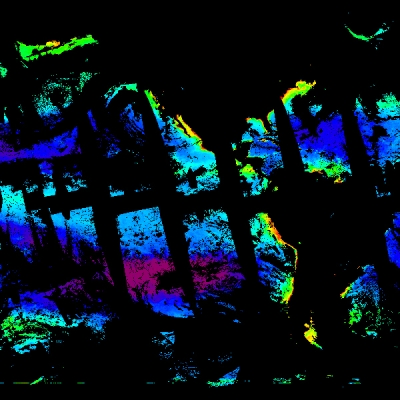
This paper provides a comprehensive overview of a specific methodology to monitor rainfall on a global scale. It is noted that while rainfall patterns are highly variable in space and time, the network of conventional ground-based instruments designed to measure rainfall is extremely sparse, even in populated areas. Over oceans there are virtually no direct measurements of rainfall. Satellite remote sensing would appear to be the most effective way to solve this problem. There is a long history of efforts to estimate rainfall from visible and infrared satellite measurements. However, there is only a tenuous physical connection between the observed radiances and rainfall estimates, while, in contrast, microwave measurements can be understood in terms of well established physics.
For detection of interannual changes in rainfall, or even a climate change, one must have a great deal of confidence in the calibration of the measurements. One can have more confidence in the stability of an instrument where algorithms are soundly based in physics and have physically based mechanisms which can be adjusted for changing circumstances, compared to empirical calibration constants which may change seasonally or regionally. Although satellite passive microwave data have been available for more than 20 years, it was the launch in 1987 of the Defense Meteorological Satellite Program (DMSP) Special Sensor Microwave Imager (SSM/I) series that has provided a new era of data continuity and quality. The NOAA/NASA Pathfinder Program is designed to assure that certain key data sets of particular significance to Global Change Research are identified, scientifically validated and made readily available, at minimum cost, to the research community. One of the key data sets identified is that of the DMSP SSM/I. Level 2 (swath) SSM/I brightness temperature data, such as those used to support this study, are being distributed by NASA's Global Hydrology Resource Center (GHRC) Distributed Active Archive Center (DAAC) while the level 3 (Earth-gridded) SSM/I brightness temperature data are being processed and distributed by NASA's National Snow and Ice Data Center (NSIDC) DAAC.
There are two physical processes which may be exploited to measure rainfall, emission and scattering of radiation by the liquid and frozen hydrometeors, respectively. The relationships between rainfall and passive microwave brightness temperatures depend critically on having a low emissivity water background. Therefore, those techniques described in this paper, based on the emission of microwaves by rain drops, are essentially restricted to oceans. At frequencies below about 40 GHz over an ocean background the relationship between the rainfall and the observations is particularly well understood. Over land, the high and variable surface emissivity makes emission a very weak source of information. Thus all SSM/I algorithms that work over land depend on the scattering-induced decrease in brightness temperature at 85.5 GHz as the dominant, if not the sole source of information.
This paper examines the principles and implementation of several (16 individual algorithms) approaches to estimating rainfall from passive microwave measurements. None of the algorithms discussed are entirely empirical. At a minimum, all of the algorithms use insights derived from radiative transfer models to select which brightness temperatures, or functions of brightness temperatures, are used as independent variables in a regression against some form of ground truth. At the other end of the scale, some algorithms use storm scale hydrodynamic models including cloud microphysics to generate the inputs to the radiative transfer models.
Although there are many advantages to microwave radiometric estimates of rain, a number of uncertainties still remain. These include the need to know the rain layer thickness as well as the contribution to the brightness temperature from the non-precipitating component of the cloud. For those algorithms which are applied over land surfaces, a problem results from the fact that rainfall is not the only scatterer of microwave radiation.
Dry snow and dry sand can also scatter significantly and the signal may be misinterpreted to be rainfall. Finally, all of the algorithms discussed use measurements from satellites in sun-synchronous orbits and as a result can only observe a small fraction of the total daily rainfall at any specific location. While the algorithms documented in this paper are considered state-of-the-art, it is noted that they are nevertheless only a snapshot of an evolving process which will result in significant improvement of the algorithms over time.
A key element in the success of improved future algorithms for rainfall, as well as other geophysical products derived from satellite passive microwave data, will be the continued role of NASA's Earth Observing System Data and Information System (EOSDIS) DAAC system in the generation of stably calibrated long time series data sets from operational satellites and the efficient and timely distribution of these data sets to the Earth science community.
References
Wilheit, T., R. Adler, S. Avery, E. Barrett, P. Bauer, W. Berg. A. Chang, J. Ferriday, N. Grody, S. Goodman, C. Kidd, D. Knieveton, C. Kummerow, A. Mugnai, W. Olson, G. Petty, A. Shibata, and E. Smith. 1994. Remote Sensing Reviews. 11:163-194.
For more information
NASA National Snow and Ice Data Center Distributed Active Archive Center (NSIDC DAAC)
Special Sensor Microwave Imager (SSM/I)
| About the remote sensing data used | ||
|---|---|---|
| Data | Defense Meteorological Satellites Program (DMSP) Special Sensor Microwave Imager (SSM/I) |
|
| Parameter | rainfall | |
| DAAC | NASA National Snow and Ice Data Center Distributed Active Archive Center (NSIDC DAAC) | |
