A few years ago, a man moved back to his family farm in Burgundy, France. Among other updates to the centuries-old farmhouse, he wanted to install a water heater in an old closet. However, the closet turned out to have a false bottom. In the darkness below, the man discovered yellowed paperwork: records of the farm’s history going back to the 1500s, mysteriously placed there for safekeeping generations before.
The discovery of documents and objects from generations past makes for fascinating stories. However, these family records can also help scientists and researchers piece together an entire region’s history, one bit of information at a time.
Carole Crumley, a professor of anthropology and ecology at the University of North Carolina at Chapel Hill, likes to tell the story of this man’s hidden family archive as a way of introducing a research project that she has been working on in Burgundy for more than two decades. The project relies on dozens of researchers using every tool in their toolbox: historic family records like those hidden in the farmhouse closet; oral histories from current residents; analysis of the structure of Medieval outbuildings; pollen in sediment cores from farm ponds; analysis of river channels; linguistic studies of Latin place names; and even satellite remote sensing data. Each of these individual resources provides one thread in a larger story that, taken together, weaves a broad and deep narrative of the region’s development and helps scientists understand the interaction of land and people through time.

The Burgundy region drew Crumley’s interest for a long-term study because hundreds of cultures—from Iron Age settlers to Romans to commoners of the Middle Ages—have inhabited the region for centuries. Crumley said, “This region is a laboratory of antiquity. It has been occupied for more than 200,000 years.” In looking at the ongoing interaction between the land and the people who have lived in the region, Crumley realized that she would have to focus not just on the archaeology, but on each culture’s use of the surrounding resources. “We simply couldn’t talk about the people without talking about the environment around them,” she said.
Weaving the narrative
At the same time that the Burgundy project began, a new technology fired the minds of scientists: satellite remote sensing allowed researchers to see our planet from a new vantage above Earth. However, most of the scientists involved in early remote sensing work were in Earth science, not anthropology. Scott Madry, a self-described technologist, studied with Crumley at the start of the long-term Burgundy work. Madry was fascinated by the possibility of using geoinformatics —a combination of remote sensing data, ground observations encoded to geological coordinates, and Geographic Information System (GIS) data—to study how people and the environment have interacted in Burgundy through the centuries. He said, “I wanted to figure out how we could apply new geoinformatics technologies, like remote sensing, to solve some of the problems of organizing long-term research like our Burgundy project.”
Now, some twenty-five years later, Madry can still remember the exact date of the first satellite remote sensing data set that he used. “It was the March 22, 1973, Multi-spectral Scanner data from NASA,” he said. “I remember thinking, ‘Wow! I can get an exact number of hectares of forest, just like that!’ Traditional methods can take months.”

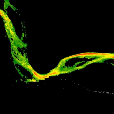
Beginning with that first data set, and continuing to incorporate remote sensing and other geoinformatics data as it becomes available, Madry has compiled a detailed database of the Burgundy study area. He has used data from European and United States sensors, including the Advanced Spaceborne Thermal Emission and Reflection Radiometer (ASTER), distributed by the Land Processes Distributed Active Archive Center (LP DAAC), and RADARSAT-1 data supported by NASA's Alaska Satellite Facility DAAC (ASF DAAC). “Each data set fills an important gap,” he said. “For example, the RADARSAT-1 data filled in an important gap in information about vegetation cover in the late 1990s, when we were seeing a lot of land-use changes in our study area.” Because he uses so many types of data, one of his students told Madry, “You’re like a vacuum cleaner; any data that gets near you is in danger.”
But how does the birds-eye view of geoinformatics intersect with the on-the-ground realm of anthropology? “Everything we’re doing relates to space and time, whether it’s carbon dating or an archaeological object at the centimeter scale,” Madry said. “The database provides spatial and temporal data, putting the rest of the research into a scaleable, concrete context.” By providing a common context for their interaction, the database allows the many specialists involved in the Burgundy project to build on each other’s work. “Each specialty brings a piece of the whole to the bigger story,” Madry said. “And that helps us understand the complexities of the changes in Burgundy through time.”
Crumley said, “I think Scott Madry has something like 130 layers of different types of information in the database, at this point.” The layers include information taken from historical maps, church ledgers, tax and legal records, oral histories, sediment research, and geological studies—all woven together within the loom of the remote sensing and other geoinformatics data. The database has allowed researchers to organize and overlay all of these disparate pieces of information about the Burgundy study area, helping the group to see patterns and commonalities across cultures and time. “We couldn’t do this kind of long-term anthropological work without it—the geoinformatics piece has been our anchor,” Crumley said.

Climate change and history
Tackling big questions that span broad periods of time and that cause profound societal changes is one of the goals of the long-term Burgundy research project. One idea that Crumley has focused on, recently, is the idea that species diversity and a varied landscape have increased the long-term survival of farms in the Burgundy study area. Crumley said, “In the 1980s, we started to see patterns in the data that suggested that France had undergone periods when the agricultural system collapsed. We looked at the Burgundy study region to determine why that occurred. Species diversity and landscape variability played a central role.”
Crumley believes that successful survival stems from flexibility in the face of change. “If the chickens didn’t do well, perhaps the rabbits did okay; or if flooding ruined crops in one area of the farm, perhaps a higher area stayed dry,” Crumley said. “Farmers and their communities are able to survive change better if they have a redundant and diverse system of crops and a variety of microclimates to farm.” To take a well-known example from history, the 1845 potato fungus that hit Ireland occurred at a time when English landowners appropriated the region’s wheat. Millions of peasants were forced to rely on a single variety of potatoes as their sole food source. Without species diversity, millions of Irish starved as the potato blight took hold.
The question of diversity and adaptability also has interesting implications for today’s society. Aided by remote sensing data, anthropologists have noted that Burgundy forests are increasingly made up of a single species of conifer.

They also observe that the number of farms has decreased by 50 percent, while doubling in size in the last fifty years. Crumley’s research indicates that many of these changes are inadvertently caused by new European Union (EU) regulations that encourage high production and provide subsidies when certain conditions are met. “The EU regulations have a one-size-fits-all approach, rather than taking into account the different conditions on the ground and the standard practice in different regions,” Crumley said. Sometimes, regulations and farm subsidies that are intended to encourage efficiency or increase food production have unanticipated consequences. “For example, the removal of Burgundy’s hedgerows to increase room for more cattle actually turns out to be bad for cows,” she said. “In the textbook climate-change-caused heat wave that hit Europe in 2003, most of the cattle that died were lost to heat stroke. They died because they couldn’t find shade.”
For Crumley, this chain of events has some eerie parallels with events in Roman times. “During the early Roman empire, Burgundy was a breadbasket for the many hungry mouths in Rome. But Romans not only brought their crops north with them; they also brought mono cropping and slave labor for big farms,” Crumley said. In other words, the Romans reduced diversity and moved away from flexible family-run farms, making them vulnerable to environmental changes like drought or pestilence. “Starting in around 200 AD, the weather worsened,” Crumley said. “Crops declined, malnourishment led to plagues, and the population of Europe decreased by half. Disastrous circumstances tend to cascade. The combination of a reckless land-use policy, social changes, and a changing climate pushed Europe into the Dark Ages.”
Long term and into the future
Crumley and Madry both intend to continue contributing to the long-term Burgundy research project, as well as encourage new researchers to use and add to the database. Crumley is focusing her efforts on writing a book about the Burgundy study region, as well as continuing to study the effects of EU regulation on family farms in the study area. She is also working with various International Geosphere-Biosphere Programme committees that study the history of human beings and the Earth system, with the goal of improving our planet’s and humanity’s future.

Madry plans to keep current on the latest satellite data and find ways to strengthen the temporal and spatial content in the database. He said, “Recently, I’ve been looking at incorporating additional historical cartographic products. I’d like to try to work backwards in time from the remote sensing and GIS data.” Adding data from old maps could clarify the picture leading up to the satellite era and strengthen the older spatial and temporal data. The central challenge for Madry lies in stitching together such disparate data into the existing foundation of the database. “How reliable are the scales on these old maps? How can they be integrated into our existing geographic material? These are the questions I’ll be tackling.”
The long-term database—a tapestry of histories and knowledge—will continue to grow and stretch as new researchers join the project and new remote sensing technologies strengthen the existing foundation. “If we can understand one place over a long period of time from many perspectives, then we can integrate this information and, in the end, help the next generation of researchers to understand complex issues like global warming and land-use change,” Madry said. “I’d never thought of it this way, before, but I guess the database is really a data archive.”
Crumley agreed. “And when you go into archives, you never know what you’re going to come across,” she said. “Except that you’ll find things that electrify.”
References
Crumley, C. 2000. From garden to globe: Linking time and space with meaning and memory. In The way the wind blows: Climate, history, and human action, Columbia Series in Historical Ecology , ed. William L. Balee and Carole L. Crumley, 193–208. New York: Columbia University Press.
Crumley, C. 2007. Historical ecology: Integrated thinking at multiple temporal and spatial scales. In The world system and the Earth system: Global socioenvironmental change and sustainability since the Neolithic , ed. Alf Hornborg and Carole Crumley, 15–28. Walnut Creek, CA: Left Coast Press.
Madry, S. In press. An evaluation of Google Earth for archaeological exploration and survey. In Proceedings of the Computer Applications and Quantitative Methods in Archaeology Meeting . Fargo, North Dakota.
Madry, S. 2005. Archaeological applications of remote sensing. Remote sensing for GIS managers. Stan Aronoff, ed. Redlands, California: ESRI Press.
For more information
NASA Alaska Satellite Facility Distributed Active Archive Center (ASF DAAC)
NASA Land Processes DAAC (LP DAAC)
GIS and Remote Sensing for Archaeology: Burgundy, France
University of North Carolina at Chapel Hill
| About the remote sensing data | |||
|---|---|---|---|
| Satellites | Terra | RADARSAT-1 | Earth Resources Technology Satellite-A |
| Sensors | Advanced Spaceborne Thermal Emission and Reflection Radiometer (ASTER) | Synthetic Aperture Radar (SAR) | Multispectral Scanner |
| Data sets | Multispectral Visible and Near Infrared (VNIR), Shortwave Infrared (SWIR), and Thermal Infrared (TIR) bands |
C band | Multispectral Scanner bands, visible and infrared |
| Resolution | 15, 30, and 90 meters | 10 and 30 meters | 80 meters |
| Parameters | Vegetation and land use/land cover | Vegetation and land use/land cover | Vegetation and land use/land cover |
| DAACs | NASA Land Processes Distributed Active Archive Center (LP DAAC) | NASA Alaska Satellite Facility DAAC (ASF DAAC) | Originally acquired by NASA; now managed by the United States Geological Survey |