From space, a kaleidoscope of aquamarine and green can be seen swirling around Earth’s oceans each spring. Algae glide near the water’s surface, soaking up sunlight and reflecting green-blue hues back to satellites. Their color reveals patterns of ocean currents and marks the abundant sea life that feed on them, from toothpick-size krill to whales weighing many tons.
Scientists are anticipating changes, though. Algae rely on phenomena called deep water masses to mix the ocean and dredge up nutrients from the seafloor, in effect seeding the water so they can bloom in spring. Yet warmer wind and ocean temperatures could weaken these currents. Pierre-Amaël Auger, a researcher at the Instituto Milenio de Oceanografía, said, “If there’s no wind and no mixing to bring nutrients to the top, there’s no fish.”
Researchers like Auger have eyed chlorophyll, the bright green pigment that gives algae their color, in satellite images since the late 1970s as a way to study ocean mixing. What has been missing was a longer case study on deep water masses. How they form is not completely understood. Marine Herrmann, Auger’s colleague and a researcher at Laboratoire d’Etudes en Géophysique et Océanographie Spatiales, said, “If you want to understand how they work, you need to understand how they vary.” So they took a closer look at the Mediterranean Sea, an area where deep water masses regularly form and feed algae.

Circulation and phytoplankton
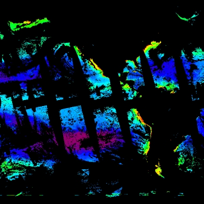
To study deep water masses, Herrmann and Auger have long kept tabs on algae, or phytoplankton, by monitoring chlorophyll. More green chlorophyll is a giveaway for phytoplankton blooms. No green is a sign that deep mixing has diluted chlorophyll in an area. When deep waters circulate, Herrmann said, “It’s very blue; there’s nothing to see in the images, no green at all.”
Year after year, they have observed the same seasonal cycle: deep mixing in winter followed by spring blooms. To bloom each spring, phytoplankton need the water’s surface to be well stocked with minerals and nutrients, and deep mixing in winter delivers them. When spring sunlight warms the water, places like the Mediterranean Sea and temperate North Atlantic explode with emerald color. Mixing wanes with spring warm up, allowing phytoplankton to float near the surface. The calm seas leave them to the task of turning sunlight into energy, of photosynthesis. And less wind and wave turbulence allows the water to settle until winter kicks off another season of deep mixing.
The best way to observe this happening in the Mediterranean, Herrmann reasoned, was to contact Auger in Chile. Auger specializes in ocean models and could recreate the conditions that exist when a deep water mass forms. By stitching together chlorophyll and other ocean measurements from three different models, he created a new model that spanned 38 years. That made Auger’s model four times longer and twice the resolution than had been seen before.
After poring over the model results, Herrmann noticed something odd. She had been tracking a deep water mass in the Mediterranean when she spotted green appearing in winter. It appeared during unseasonably warm winters, which suggested deep mixing had stalled with added heat. She needed to dig deeper to be sure.

Deep sea diving
In the Mediterranean Sea, deep mixing is triggered each winter by frigid winds from the Alps, the Massif Central, and the Pyrenees that blow across the southern lip of France and whip up water in the Gulf of Lions. In the center of the gulf, where these winds buffet the surface, the water cools and becomes heavier than the surrounding water. As a result, a mass of dense, salty water sinks. Lighter water rises in its place, creating convection that surfaces nutrients.
From the beginning, Herrmann and Auger knew they could compare chlorophyll, or lack thereof, with sea level to learn more about this deep water mass. “When water is more dense and sinking, it causes an overall depression in sea level,” Herrmann said. Lower sea levels could help show the mass as it formed, and reveal its size. “If I know the size of the blue area and the size of the dropped sea level area,” she said, “I can give you the volume of the deep convection area.”
In her balmy office in Vietnam, Herrmann crunched the numbers between chlorophyll and sea level readouts from Auger’s model. In a previous study, she had linked sea level and deep water circulation in the Mediterranean Sea using this formula, but sea level data available at the time spanned nine years. With the new model, her calculations again showed a clear link between the blue area and dropped sea level. She now had a good idea how big the deep water mass was over the 38-year period.

Intense in situ
The mass in the Gulf of Lions, called Western Mediterranean Deep Water, regularly plunges 2,400 meters (7,874 feet) to the seafloor and keeps the Mediterranean circulated and healthy. “It acts like a washing machine where everything gets mixed from top to bottom, bottom to top,” Herrmann said.
Was this deep water mass weakening over time? The answer lay in calculating its intensity—how quickly it had been forming and sinking each year. How much water had it been mixing from year to year? Was it sluggish in some years or declining overall?
Readings from oceanographic ships and drifting sensors helped her test the accuracy of their model with those questions in mind. While the ship data covered only one year and data from drifting sensors just a smattering of years, they were indispensable. Judging by temperature and salinity measurements of the upper 2,000 meters (6,562 feet) of the ocean, and how quickly they changed, Herrmann was able to estimate both the size and intensity of the Western Mediterranean Deep Water mass. Most importantly, the in situ data helped them fine-tune the model.
Like Herrmann’s earlier findings, their improved model showed a direct connection between chlorophyll and sea surface height, along with atmospheric changes, salinity, and how quickly dense water formed. It also showed how deep water masses vary from year to year, making it a more realistic case study.

Layering effect
Other modeling studies have suggested that higher temperatures may lead to significantly less frequent, less intense circulation by the end of the 21st century. Those studies make it all the more pressing to monitor deep water masses over the long term. But data have limits.
“We usually have a lot of in situ observations for just one area,” Herrmann said. One buoy in the middle of the Gulf of Lions, for instance, is loaded with sensors that log conditions from the surface to the seafloor. “This buoy is precious because it provides continuous monitoring, but it only covers one point,” she said.
Satellites have better coverage, although they too present challenges. “Satellites for these measurements don’t measure through clouds,” Auger said, “so a model can be used to fill gaps in the data.”
To get around this limitation, Herrmann created a multilayered satellite data set. With chlorophyll measurements from NASA's Sea-Viewing Wide Field-of-View Sensor (SeaWiFS) and Moderate Resolution Imaging Spectroradiometer (MODIS), she merged sea level data from nearly a dozen satellites, the result of a NASA and Centre National D’Etudes Spatiales (CNES) collaboration. She then applied the same formula for calculating the volume of the deep water mass. The data set confirmed her findings and covered 19 years, making it the first long time series of deep water convection in the northwestern Mediterranean Sea. Until now, there had only been short time series or evaluations for individual years, either from in situ or satellite data, Herrmann said.
As with the in situ data, the new satellite time series can be used to evaluate and correct models, benefitting all researchers who study deep convection. “We are helping to complement all the measurements,” Auger said. “And thanks to the models, we know more about these processes.”

Fruits de mer
Herrmann added, “Reality is much more complicated of course, so we will keep adding new elements, like information on tides.” Eventually, they plan to build long case studies for more regions where deep water masses form, such as the Greenland and Labrador Seas.
Other developments are in the works, too. A joint NASA-CNES altimetry satellite called Surface Water and Ocean Topography (SWOT) will be launched in 2020. SWOT’s sharper resolution and better spatial coverage could improve the accuracy of future studies.
“It is very difficult to monitor long-term deep convection, but it is very important,” Herrmann said. “It affects the whole ocean ecosystem. It also redistributes heat. Without deep convection, you would have a very different climate.” Teasing out the details of how these global processes work is its own process, and is ongoing. And surfacing answers inspire them to ask new questions. Auger said, “Understanding the sea couldn’t be more fascinating to me. It’s life.”
References
Auger, P. -A., C. Ulses, C. Estournel, L. Stemmann, S. Somott, and F. Diaz. 2014. Interannual control of plankton communities by deep winter mixing and prey/predator interactions in the NW Mediterranean: Results from a 30-year 3D modeling study. Progress in Oceanography 124: 12–27. doi:10.1016/j.pocean.2014.04.004.
Herrmann, M., P. -A. Auger, C. Ulses, and C. Estournel. 2017. Long-term monitoring of ocean deep convection using multisensors altimetry and ocean color satellite data. Journal of Geophysical Research: Oceans 122: 1,457–1,475. doi:10.1002/2016JC011833.
Marshall, J. and F. Schott. 1999. Open-ocean convection: Observations, theory, and models, Reviews of Geophysics 37(1): 1–64. doi:101029/98RG02739.
NASA Goddard Space Flight Center, Ocean Ecology Laboratory, Ocean Biology Processing Group. 2016. MODISA_L3m_CHL Moderate Resolution Imaging Spectroradiometer (MODIS) Ocean Color Data, NASA OB.DAAC. https://oceandata.sci.gsfc.nasa.gov/MODIS-Aqua/Mapped/Daily/9km/chlor_a.
NASA Goddard Space Flight Center, Ocean Ecology Laboratory, Ocean Biology Processing Group. 2016. MODISA_L3m_CHL Moderate Resolution Imaging Spectroradiometer (MODIS) Ocean Color Data, NASA OB.DAAC. https://oceandata.sci.gsfc.nasa.gov/MODIS-Terra/Mapped/Daily/9km/chlor_a.
NASA Goddard Space Flight Center, Ocean Ecology Laboratory, Ocean Biology Processing Group. 2016. Sea-Viewing Wide Field-of-View Sensor (SeaWiFS) Ocean Color Data, NASA OB.DAAC. https://oceandata.sci.gsfc.nasa.gov/SeaWiFS/Mapped/Daily/9km/chlor_a.
For more information
NASA Ocean Biology Distributed Active Archive Center (OB.DAAC)
NASA Moderate Resolution Imaging Spectroradiometer (MODIS)
Sea-Viewing Wide Field-of-View Sensor (SeaWiFS)
About the Remote Sensing Data
| Satellites | Terra and Aqua | GeoEye SeaStar |
| Sensors | Moderate Resolution Imaging Spectroradiometer (MODIS) | Sea-Viewing Wide Field-of-View Sensor (SeaWiFS) |
| Data sets | Level 3 Mapped Chlorophyll (MODISA_L3m_CHL), Terra Level 3 Mapped Chlorophyll (MODISA_L3m_CHL), Aqua |
SeaWiFS Global Daily Mapped 9km Chlorophyll a |
| Resolution | 9 kilometer | 9 kilometer |
| Parameter | Near-surface chlorophyll-a concentrations | Near-surface chlorophyll-a concentrations |
| DAAC | NASA Ocean Biology Distributed Active Archive Center (OB.DAAC) | NASA OB.DAAC |