Dr. Michael Dietze, Associate Professor, Department of Earth and Environment, Boston University
Research interests: Ecological forecasting, with a particular interest in integrating remotely-sensed environmental data into environmental models as a means of improving model forecasts and outputs.
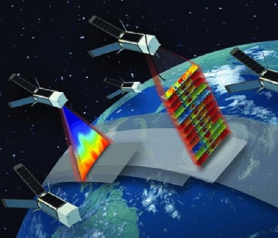
Research highlights: A model is a representation of reality. While a model of an aircraft might be built using plastic and glue, scientific models designed to represent terrestrial ecological processes are constructed using algorithms and years of Earth observing data from many sources. One of these sources is remotely-sensed data collected by instruments aboard satellites, such as the Terra and Aqua Earth observing satellites. These data facilitate the development of a wide range of individual data products that can be used to compare processes occurring in the real world with output from ecological models. NASA's Earth Observing System Data and Information System (EOSDIS), for example, currently archives almost 22 petabytes of Earth observing data from satellite, airborne, and in situ missions. Through the Earth Science Data and Information System (ESDIS) Project, EOSDIS provides access to more than 10,000 unique research products.
With so much data and so many data products, one challenge for researchers is effectively utilizing and synthesizing existing data. Through the Predictive Ecosystem Analyzer (PEcAn), Dr. Michael Dietze and his colleagues are attempting to address this challenge and improve the accuracy of ecological models by making it easier to integrate existing data into these models.
PEcAn, which was developed by Dr. Dietze, is an open-source ecoinformatics system that provides a common set of software tools that allow users to integrate multiple ecosystem models and data so they can efficiently be used together. One benefit of being able to constantly add new data or data variables to an environmental model is that the model can better represent the effects of ongoing events in a specific area to ecological processes, such as forecasting the leaf-out times of plant species in that area or region.
PEcAn manages the integration and conversion of data into environmental models along with model execution, and provides a variety of tools for analyzing and visualizing data output. Dr. Dietze and his colleagues have used PEcAn in a wide range of projects across most of the world’s terrestrial biomes.
Much of Dr. Dietze’s current research and work is focused on comparing outputs from multiple environmental models with terrestrial ecosystem data to identify cases where data can help differentiate between competing hypotheses of how Earth processes work; cases where current models do not capture a process correctly; and instances where data are insufficient to differentiate among multiple hypotheses. Dr. Dietze and his colleagues also are working on developing new ecological theories and statistical tools to better understand why certain ecological processes are more or less predictable, and then using these theories and tools to compare the sources of uncertainty that affect model forecasts of these processes.
In a recent project, Dr. Dietze led a team that examined ways of fusing predictions of leaf phenology (the date that plant leaves unfold) generated by terrestrial ecosystem models with phenological data from NASA’s satellite-based Moderate Resolution Imaging Spectroradiometer (MODIS) instrument Leaf Area Index (LAI) products and AmeriFlux Fraction of Absorbed Photosynthetically Active Radiation (fAPAR) products. MODIS is a key instrument aboard NASA’s Terra and Aqua satellites; AmeriFlux is a network of field sites measuring ecosystem carbon dioxide, water, and energy fluxes across North, Central, and South America.
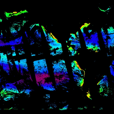
Building upon this research, Dr. Dietze is part of a team working on an approach integrating remotely-sensed data with model data that will enable terrestrial ecosystem models to predict reflectance spectra. Reflectance spectra are a measure of the wavelengths of light that are returned rather than absorbed by a plant or other object. When sunlight strikes a plant leaf, certain wavelengths of this visible light are absorbed and other wavelengths are reflected. Healthy vegetation absorbs most of the visible light that hits it (which is used for photosynthesis) and reflects a large portion of light in near-infrared wavelengths. Unhealthy or sparse vegetation reflects more visible light and less near-infrared light. By analyzing the spectra of returned radiation detected by a sensor aboard an aircraft or satellite, the composition, structure, disturbance, or other variables of vegetation can be measured.
In this work, spectral data collected over Eastern U.S. temperate forests by the Airborne Visible/Infrared Imaging Spectrometer (AVIRIS) are assimilated into models designed to analyze canopy optical properties with the goal of improving the sensitivity and accuracy of these models. As Dr. Dietze notes, once this data/model integration is successful, this approach will be applied to multispectral data, such as data from the Visible Infrared Imaging Radiometer Suite (VIIRS) aboard the joint NASA/NOAA Suomi National Polar-orbiting Partnership (Suomi NPP) satellite along with MODIS data. The research team also intends to see if this approach can be extended to Light Detection and Ranging (LIDAR) systems, such as the upcoming Global Ecosystem Dynamics Investigation (GEDI) mission, as well as thermal imagery, such as the upcoming ECOsystem Spaceborne Thermal Radiometer Experiment on Space Station (ECOSTRESS) mission, both of which will be installed on the International Space Station (ISS).
Representative data products used:
- MODIS LAI products from the Terra and Aqua Earth observing satellites [MOD15A2H (Terra), [doi:10.5067/MODIS/MOD15A2H.006]; MYD15A2H (Aqua), [doi:10.5067/MODIS/MYD15A2H.006], [MCD15A2H (Terra + Aqua), [doi:10.5067/MODIS/MCD15A2H.006], [MCD15A3H (Terra + Aqua), [doi:10.5067/MODIS/MCD15A3H.006]; available through the Land Processes Distributed Active Archive Center (LP DAAC)
- North American Land Data Assimilation System (NLDAS) and Global Land Data Assimilation System (GLDAS) data; available through the Goddard Earth Sciences Data and Information Services Center (GES DISC)
- Common Readout Unit-National Centers for Environmental Prediction (CRU-NCEP) climatology data from the North American Carbon Program (NACP); available through the Oak Ridge National Laboratory DAAC (ORNL DAAC)
- AVIRIS data over eastern temperate forests; available through the AVIRIS Data Products Portal
- AmeriFlux fAPAR data; available through the AmeriFlux website
- National Land Cover Database; available through the Multi-Resolution Land Characteristics Consortium, a partnership of Federal agencies led by the U.S. Geological Survey
- North American Regional Reanalysis data; available through NOAA's National Centers for Environmental Information
Read about the research:
Shiklomanov A., Dietze, M.C., Viskari, T., Townsend, P.A. & Serbin, S.P. (2016). “Quantifying the influences of spectral resolution on uncertainty in leaf trait estimates through a Bayesian approach to RTM inversion.” Remote Sensing of Environment, 183: 226-238 [doi:10.1016/j.rse.2016.05.023].
Viskari, T., Hardiman, B., Desai, A.R. & Dietze, M.C. (2015). “Model-data assimilation of multiple phenological observations to constrain and predict leaf area index.” Ecological Applications, 25(2): 546-558 [doi:10.1890/14-0497.1].
For more information
- Moderate Resolution Imaging Spectroradiometer (MODIS)
- Airborne Visible/Infrared Imaging Spectrometer (AVIRIS)
- Visible Infrared Imaging Radiometer Suite (VIIRS)
- Suomi National Polar-orbiting Partnership (Suomi NPP)
- Global Ecosystem Dynamics Investigation (GEDI) mission
- ECOsystem Spaceborne Thermal Radiometer Experiment on Space Station (ECOSTRESS)