Dr. Nancy French, Senior Scientist, Michigan Tech Research Institute; Adjunct Professor, School of Forest Resources and Environmental Science, Michigan Technological University
Research interests: Applications of remote sensing to ecology and vegetation studies.
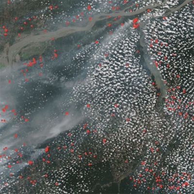
Research highlights: The ingredients necessary to create a wildland fire are simple: a source of fuel, heat to bring the fuel to its ignition temperature, and oxygen to sustain the resulting combustion. As the fire burns, it releases smoke and other emissions. One of these emissions is carbon, the sixth most abundant element in the universe and an essential component of life on Earth. Carbon is continually cycled through processes such as burning and the decay of organic material. The integrated processes of wildland fire and carbon cycling form the cornerstones of Dr. Nancy French’s research.
French uses remote sensing data and the application of remote sensing techniques to study forest ecosystems. More specifically, her research focuses on wildfires and the effects of these fires on the structure and function of ecosystems along with the impacts of wildfires to carbon cycling, energy balance, and air quality. Her research relies on a variety of remote sensing techniques to study vegetation, including synthetic aperture radar (SAR) images and data from multi-spectral sensors such as the joint NASA/USGS Landsat series of satellites and the Moderate Resolution Imaging Spectroradiometer (MODIS) instrument aboard the Aqua and Terra Earth observing satellites. French also works with modeling experts to use NASA-developed models, such as the Carnegie-Ames-Stanford Approach biosphere model, to predict future impacts on ecosystems based on past fire and ecosystem observational data. Examples of her recent research show the application of these various components.
In one NASA study, French used geospatial and remote sensing methods to better understand, verify, and quantify expected increases in the number of wildfires in tundra ecosystems due to global climate change and predict future fire potential in northern Alaska. Data from MODIS along with Landsat optical imagery were used to assess changes in burn scars over time. In addition, SAR imagery from the European Space Agency’s European Remote Sensing Satellites (ERS-1/2) and the Japan Aerospace Exploration Agency’s Advanced Land Observing Satellite-1 (ALOS-1) were used to assess burned areas and the impacts of fire on changes in the amount of radar energy reflected from the land surface. The use of MODIS, Landsat, and SAR imagery enabled a broad assessment of fire-impacted areas using a wide range of spectral bands (infrared, visible, and microwave). Images produced from these data allowed changes in these burn areas to be tracked over time as vegetation recovered. This research continues as part of the Arctic-Boreal Vulnerability Experiment (ABoVE).
French also received NASA funding to develop methods for evaluating wildland fire emissions and fuel consumption. Prior to the development of satellite-based instruments to study vegetation and burned areas, assessments of emissions from biomass burning were based on fragmentary data from fire-activity reports submitted by land managers and government agencies. The value of these fire-activity reports was limited, though, due to their lack of detailed land use and land cover type data. As a result, these reports generally had overly broad assessments of the amount and type of vegetation burned and the characteristics of the burning. Through the use of remotely sensed data, French and her colleagues were able to more accurately assess vegetation type and ecological conditions in a burn area. These observations, combined with field data, led to the development of more precise methods for understanding the variability in wildfire emissions arising from the type of vegetation that is burned and the proportion of this fuel that is consumed.
Finally, French participated in several studies evaluating the effectiveness of satellite-based data (such as SAR and multi-spectral optical data) in assessing fire extent and severity, mainly in boreal, tundra, and peat environments. The multi-spectral optical data used included the Landsat-derived Normalized Burn Ratio (NBR) and differenced Normalized Burn Ratio (dNBR) algorithms, which use Landsat Thematic Mapper (TM) and Enhanced Thematic Mapper Plus (ETM+) imagery to map the variability of vegetation cover at burn sites. The research team specifically looked at the effects of fire on soil water status, surface fuel consumption, and post-fire vegetation recovery. They compared data derived from remotely-sensed metrics (such as NBR and dNBR) with data derived from field metrics (such as the Composite Burn Index [CBI], which is a measure of burn severity based on ground observations that attempts to numerically describe the ecological consequences of a fire). This research was mainly focused on fires in Alaska, but also included sites in Russia and in western U.S. states.
Data products used:
- MODIS data sets:
- Vegetation Continuous Fields, MOD44A (Terra, composite) and MOD44B (Terra, annual), both of which are available through the Land Processes Distributed Active Archive Center (LP DAAC)
- Level 3 8-Day Daily Composite Fire Product, MOD14A1 (Terra) and MYD14A1 (Aqua), both of which are available through LP DAAC
- Burn Area (MCD64A1); available through the Wildland Fire Emissions Information System (WFEIS) website
- Albedo (MCD43A3) at 1000 m; available through LP DAAC
- Various data sets from the Advanced Spaceborne Thermal Emission and Reflection Radiometer (ASTER) instrument; available through LP DAAC
- ERS-1/2 SAR data; available through the Alaska Satellite Facility DAAC (ASF DAAC)
- ALOS-1 PALSAR data; available through ASF DAAC
- Landsat TM and ETM+ data; available through the U.S. Geological Survey’s Earth Explorer interface and Global Visualization Viewer (GloVis) data viewer
Research findings and outcomes: In her work investigating potential changes in the number and scope of tundra wildfires due to global climate change, French and her colleagues found that small tundra fires, defined in their research as those with a mean size of 2,452 acres (almost 10 km2) and a median size of 16 acres (0.06 km2), are common. As a rough size estimate, one acre is slightly smaller than the size of an American football field. With an increase in warmer summers and an extended period of vegetation drying, fire activity is expected to increase in this region. Another tundra study used MODIS data to assess changes in the amount of light and radiation reflected from a surface, or albedo. Wildfire has a strong impact on albedo since burned vegetation darkens the surface, which leads to less light and radiation being reflected and more solar radiation being absorbed. This, in turn, can lead to greater warming of the upper soil layers in these darker, burned areas that can impact productivity. French found that there was a marked decrease in the amount of reflected light from a burned area in the year following a fire, but that areas in her study returned to pre-fire albedo levels in roughly four years.
Through her NASA-funded fire emissions and fuel consumption research, French and her colleagues note that remotely-sensed data provide information about several factors that are required for estimating carbon emissions from wildfires: the fire’s spatial extent; the fuel type, fuel load, and plant physiological and moisture conditions; site characteristics before and after the fire event; and environmental factors during the fire that can influence fire intensity and severity (such as wind speed and direction, changes in humidity, and atmospheric temperature profiles). This work led to the development of the Wildland Fire Emissions Information System (WFEIS). WFEIS provides a simple interface for computing wildland fire emissions across the continental U.S. and Alaska at landscape to regional scales. WFEIS also provides access to the spatial data and models needed to compute emissions from fires within the WFEIS fire database. Using MODIS burn area products or Landsat-based burn perimeters mapped by the USGS (which are available through the Monitoring Trends in Burn Severity (MTBS) project, WFEIS is able to compute emissions for anywhere within the U.S. that is known to have burned.
French’s work evaluating the benefits of using remotely sensed data for assessing fire and fire effects showed the necessity of combining remotely-sensed data with field measurements. As she and her co-authors note, while satellite data can be invaluable for mapping and determining variables such as fire perimeters, especially in remote areas, a combination of satellite images and data gathered from field investigations is necessary for a complete understanding of fire effects. French notes that MODIS products provide information on the spatial locations of fires and burn areas that are essential for quantifying fire emissions and for mapping the ecological consequences of fire. Vegetation mapping and monitoring from MODIS, ASTER, and Landsat provide important information about site ecology as well as actual and potential fire emissions that can be combined with data from field investigations to create a more precise, ecologically-based assessment of fire effects. French and her colleagues also developed ways to use SAR imagery for mapping soil moisture in areas of low stature vegetation and for assessing soil moisture in sites within boreal Alaska where permafrost is present.
Read about the research:
French, N.H.F., Whitley, M.A. & Jenkins, L.K. (2016). Fire disturbance effects on land surface albedo in Alaskan tundra. Journal of Geophysical Research: Biogeosciences 121(3). doi:10.1002/2015JG003177
French, N.H.F., Jenkins, L.K., Loboda, T.V., Flannigan, M., Jandt, R., Bourgeau-Chavez, L.L. & Whitley, M. (2015). Fire in arctic tundra of Alaska: past fire activity, future fire potential, and significance for land management and ecology. International Journal of Wildland Fire 24(8). doi:10.1071/WF14167
French, N.H.F., McKenzie, D., Erickson, T., Koziol, B., Billmire, M., Endsley, K.A., Scheinerman, N.K.Y., Jenkins, L., Miller, M.E., Ottmar, R. & Prichard, S. (2014). Modeling regional-scale fire emissions with the Wildland Fire Emissions Information System. Earth Interactions 18. doi:10.1175/EI-D-14-0002.1
French, N.H.F., de Groot, W.J., Jenkins, L.K., Rogers, B.M., Alvarado, E.C., Amiro, B., de Jong, B., Goetz, S., Hoy, E., Hyer, E., Keane, R., McKenzie, D., McNulty, S.G., Law, B.E., Ottmar, R., Perez-Salicrup, D.R., Randerson, J., Robertson, K.M. & Turetsky, M. (2011). Model comparisons for estimating carbon emissions from North American wildland fire. Journal of Geophysical Research 116. doi:10.1029/2010JG001469
French, N.H.F., Kasischke, E.S., Hall, R.J., Murphy, K.A., Verbyla, D.L., Hoy, E.E. & Allen, J.L. (2008). Using Landsat data to assess fire and burn severity in the North American boreal forest region: an overview and summary of results. International Journal of Wildland Fire 17(4). doi:10.1071/WF08007
For more information
- Moderate Resolution Imaging Spectroradiometer (MODIS)
- Arctic-Boreal Vulnerability Experiment (ABoVE)
- Landsat Thematic Mapper (TM)
- Enhanced Thematic Mapper Plus (ETM+)
- Wildland Fire Emissions Information System (WFEIS)
- Advanced Spaceborne Thermal Emission and Reflection Radiometer (ASTER)
- Monitoring Trends in Burn Severity (MTBS)