People often picture wind turbines rooted in waving fields of golden grass, but wind turbines can also stand among the waves of coastal waters. Offshore wind offers more than just clean and economical energy; winds over the ocean can often be faster and fluctuate less than land-based winds, leading to higher and more sustained output. Offshore wind sites tend to be naturally close to the large coastal population centers that need their power, and they do not have to compete for valuable land. Willett Kempton, a professor at the University of Delaware, said, “Offshore wind power is particularly attractive because the resource is large and current technology is ready for implementation now.”
So if wind energy can provide the world with clean power, why are turbines not up and spinning along every coastline? Developers need solid assessments of coastal wind energy potential before they consider a new wind project, information not easily available using traditional ground-based tools. In an effort to help assess wind energy potential, Kempton and his colleagues are using an unexpected tool: satellite data. Their latest project focuses on the undulating coastline of Brazil.

Location, location
Whether along the coast of northern Europe, the United States, or Brazil, cost-effective wind turbine sites have a few specific requirements. First, wind speeds must fall within a defined zone. Kempton said, “The ideal wind-speed zone has winds that are high enough to produce energy but without strong storms that pose a threat to the installation.” Second, offshore turbine foundations must be on relatively shallow coastal shelves; the deepest installed turbine is currently rated for 50 meters (164 feet) in depth. Finally, the site must be able to accommodate the whirling blades of enough turbines to be cost-effective. Kempton said, “The idea is to fan them out and make sure they are spaced apart appropriately for effective energy production.”
While the wind industry and turbine manufacturers are concerned with all of these details, scientists are, too. “Coastal zone assessment is the piece that scientists, like our team, can provide,” Kempton said. “Think of it like petroleum or coal: you need a resource assessment so that you have a sense of how much resource is located where, and how you’ll need to extract it. That’s what we need to do with offshore wind.”
One of the most recent and promising wind assessment studies that Kempton and his colleagues Richard Garvine and Felipe Pimenta developed was to determine wind energy potential off the coast of southeastern Brazil. Pimenta, a native of Brazil, said, “My goal is to search for renewable energy solutions that can help diversify the Brazilian electric grid.”
Assessing a Brazilian wind
Most of Brazil’s electricity comes from hydroelectric dams, with a sizable portion from traditional fossil-based resources and only a small percentage coming from renewable resources like wind. Now Brazil wants to increase its share of renewable energy. Pimenta said, “A new government program, ProInfra, seeks to increase the use of new renewables to 10 percent of our annual electricity consumption. Our study is important because it is the first to evaluate Brazil’s offshore wind potential.”
With its bustling, coast-hugging population centers like São Paulo and Rio de Janeiro, offshore wind is a promising fit for Brazil. “Brazil has a long coastline and vast continental shelves, and it seems to have even more wind resources than we might have expected,” Pimenta said.

Typically, wind energy assessments begin by analyzing data from continuously operating meteorological stations on buoys that float offshore near the potential site. These stations measure wind speed up to twenty meters (sixty-six feet) above the sea surface. From these measurements, scientists extrapolate the wind speed at the turbine’s hub height, approximately 80 meters (262 feet), to get an idea of the wind available to turn a turbine’s blades. Researchers also use station data to analyze wind speed fluctuations from one minute to the next. However, meteorological data from buoys and fixed platforms can be hard to get. Kempton said, “Many countries simply lack historical meteorological buoy information over the ocean.” The chosen study area turned out to be a good example of the sparseness of meteorological station data. Kempton said, “For the entire study area, we only had two offshore buoys available.”
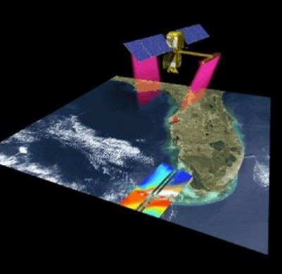
Given the dearth of wind speed data from meteorological stations, the team needed a different source. “In a new offshore wind power seminar we teach at the University of Delaware, student Oleksiy Kalynychenko suggested using NASA QuikSCAT data. Felipe decided to try it,” Kempton said. “To our knowledge, this study is the first to use QuikSCAT to assess wind power resources over a large ocean area.” The SeaWinds instrument, aboard the QuikSCAT satellite, provides scatterometer data that is hosted by NASA's Physical Oceanography Distributed Active Archive Center (PO.DAAC). The instrument measures ocean roughness and relates it to wind speed at the ocean surface. “QuikSCAT has exceptional global geographic coverage at a very reasonable spatial resolution, from just over twelve to fifty kilometers [seven to thirty-one miles],” Kempton said. “The satellite data filled in the gaps in the vast areas around the two buoys.”
Before settling on QuikSCAT, the scientists first wanted to confirm that the satellite data correlated well to existing buoy data. “We crosschecked meteorological data from several places against QuikSCAT to ensure that we could use the satellite data for assessing the Brazilian power resource,” said Kempton. By combining the meteorological and QuikSCAT data, the team could also address a limitation of the satellite data. Wind speeds can fluctuate from minute to minute and from hour to hour, so unless data are taken continuously—as meteorological stations are able to do—those fluctuations will not be captured. Kempton said, “When the satellite passes over the study region, that’s when you get the data, once or maybe twice per day. The buoys are running continuously, but in only a few places. The two together provide both spatial and temporal coverage.”
One of the two buoys within the study area was particularly helpful for this purpose because it took measurements during the same months that QuikSCAT passed overhead. “We could confirm that the satellite data was within acceptable margins of error for a first-cut evaluation of power resources,” he said. “QuikSCAT can indeed provide practical measures of wind power, especially when looking for monthly or yearly estimates.”
Where the wind blows
Having cross-referenced the buoy and satellite data, the scientists’ next step was to explore the “footing” on which turbines could stand in the study area. “Felipe got bathymetric information by digitizing Brazilian Navy nautical charts,” Kempton said. “This helped us estimate the shelf areas that are within the practical limits of exploration, in terms of depth.”

Kempton and his team now had the information needed to assess the practical wind-turbine-worthy wind resource: the wind speed at hub height over a large area from the satellite data; an idea of the fluctuations of wind speed based on the hour and season from both buoy and satellite data; and the depth of the continental shelf, where the turbines would be planted, from the bathymetric data.
Using all of this information, Kempton, Garvine, and Pimenta calculated the potential power production for two different wind turbine models. Kempton said, “The total average electricity use of Brazil is near 100 gigawatts, and the offshore wind resource of this one section of coast, to only 50 meters [164 feet] of water, is 102 gigawatts.” That means that if the study area were fully developed as a wind energy project, it could supply enough electricity for the entire country’s electricity needs.
“However,” Kempton said, “there would certainly be areas that would be excluded from development, and we didn’t attempt to consider those in our calculation. According to previous studies, exclusions for shipping lanes, marine conservation sites, and commercial fishing, could reduce the site’s capacity by 10 to 46 percent.” Even with such areas excluded from development, an offshore wind project in the study region could still meet ProInfra’s efforts to increase Brazil’s renewable energy output.
Kempton feels optimistic about the future of the team’s work. He said, “The work on the Brazilian wind assessment was the first step in a larger picture. We hope to make a database of wind assessments available for various coastal areas, with wind resource, energy demand, potential electrical output and revenue, and so on. We think this would help the wind industry decide whether or not a site is feasible economically and help with government planning.”
Pimenta agreed, adding, “I want to return to Brazil and continue this work. There are still many tools, including satellite data, left for us to explore as we look at wind energy. I hope our work will help other large countries estimate their wind resources, too.” A better understanding of global offshore wind potential could help many countries reduce their portion of humanity’s carbon output.
The main message, from Kempton’s perspective, is one of hope. “In the end,” he said, “people really understand the results of this type of research. They say things like, ‘Wow, this makes me very optimistic. I thought climate change was all doom and gloom. But we can actually do something to turn it around.’ And, given the technologies already available today, offshore wind is one of the best options out there.”
References
Kempton W., C. L. Archer, A. Dhanju, R. W. Garvine, M. Z. Jacobson. 2007. Large CO2 reductions via offshore wind power matched to inherent storage in energy end-uses. Geophysical Research Letters 34, L02817, doi:10.1029/2006GL028016.
Pimenta F., W. Kempton, and R. Garvine. 2008. Combining meteorological stations and satellite data to evaluate the offshore wind power resource of Southeastern Brazil. Renewable Energy, doi:10.1016/j.renene.2008.01.012.
For more information
NASA Physical Oceanography Distributed Active Archive Center (PO.DAAC)
NASA Quick Scatterometer (QuikSCAT) satellite
Centre ERS d’Archivage et de Traitement [French ERS Processing and Archiving Facility] (CERSAT)
Willett Kempton, University of Delaware, College of Marine and Earth Studies
| About the remote sensing data | ||
|---|---|---|
| Satellite | QuikSCAT | |
| Sensor | SeaWinds Scatterometer | |
| Data set | Level 2B Ocean Wind Vectors in 25 km Swath Grid and 12.5 km Swath Grid | |
| Resolution | 12.5 and 25 kilometer | |
| Parameter | Wind vectors | |
| DAAC | NASA Physical Oceanography Distributed Active Archive Center (PO.DAAC) | |