Home
Mobile Menu
Skip to main content
  • About
  • Data
  • Collaborate
  • Learn

LANCE: NASA Near Real-Time Data and Imagery

  1. Earth Observation Data
  2. LANCE: NASA Near Real-Time Data and Imagery
Share on Twitter Share on Facebook Share on Pinterest

Land, Atmosphere Near real-time Capability for EOS (LANCE)

LANCE logo

NASA's Land, Atmosphere Near real-time Capability for EOS (LANCE) supports users interested in monitoring a wide variety of natural and man-made phenomena using near real-time (NRT) data and imagery that are made available much quicker than routine processing allows.

Most data products are available within 3 hours from satellite observation. Imagery are generally available 3-5 hours after observation. If latency is not a primary concern, users are encouraged to use the standard science products, which are created using the best available ancillary, calibration and ephemeris information.

More

  • About LANCE
  • What is Data Latency?
  • Near Real-Time versus Standard Products
  • Data outages and known issues
  • LANCE Mailing Lists
  • Disclaimer and Citation
  • 10 LANCE milestones over the past decade
  • Other NRT / Low Latency / Expedited Data from NASA
Discover NRT Data and Imagery

Download Data

  • AIRS - Atmospheric Infrared Sounder
  • AMSR2 - Advanced Microwave Scanning Radiometer 2
  • LIS ISS - Lightning Imaging Sensor on the International Space Station
  • ICESat-2 -  Advanced Topographic Altimeter System (ATLAS) on the Ice, Cloud and land Elevation Satellite-2 (ICESat-2)
  • MISR - Multi-angle Imaging SpectroRadiometer
  • MLS - Microwave Limb Sounder
  • MODIS - Moderate Resolution Imaging Spectroradiometer
  • MOPITT - Measurements of Pollution in the Troposphere
  • OMI - Ozone Monitoring Instrument
  • OMPS - Ozone Mapping and Profiler Suite
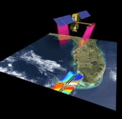
  • VIIRS-Atmosphere - Visible Infrared Imaging Radiometer Suite
  • VIIRS-Land - Visible Infrared Imaging Radiometer Suite

    Hazards and Disasters

    FIRMS: Active fire/hotspot data, maps and alerts

    Imagery

    • Overview of Near Real-Time Imagery
    • Worldview
    • Worldview Snapshots
    • Global Imagery Browse Services (GIBS)

    Fire Information for Resource Management System (FIRMS)

    FIRMS, part of LANCE, distributes NRT active fire data within 3 hours of satellite observation from both MODIS and VIIRS. The active fire / hotspot data are available to view in FIRMS Global Fire Map, FIRMS US/Canada or in NASA’s Worldview. They can also be delivered as fire email alerts or downloaded in one of the following formats: SHP, KML, TXT or as Web Services.

    • User Guides
    • FAQs
    • About FIRMS
    • LANCE FIRMS mailing list

    Links

    • Web Fire Mapper circle icon
      Fire Map - Global and US/Canada

      Interactively browse daily global MODIS and VIIRS fire locations

    • Emailalert Circle
      Fire Email Alerts

      Sign up to receive email notification of fires in your area-of-interest

    • Download circle
      Download FIRMS Data

      Download global MODIS and VIIRS fire locations in user friendly formats

    Page Last Updated: May 3, 2022 at 2:18 PM EDT

    LANCE News

    • New Low Latency ICESat-2 Datasets
    • User Profile: Dr. Margaret “Maggi” Glasscoe
    • Near Real-Time MODIS Global Flood Product Now Available from NASA’s LANCE
    • New Black Marble Nighttime Blue/Yellow Composite Product Makes Detecting Power Outages Easier
    • Near Real-Time VIIRS Dark Target Aerosol Product Now Available from NASA’s LANCE
    • NASA, Forest Service Partnership Expands Active Fire Mapping Capabilities

    Discover Data and Services

    • Earthdata Search
    • International Directory Network (IDN)
    • Data Tools

    @NASAEarthdata

    Loading Tweets by NASAEarthdata...

    We're sorry. Our Twitter feed cannot load right now.

    In the meantime, visit us below!

    @NASAEarthdata

    ABOUT

    DATA

    COLLABORATE

    LEARN

    USER RESOURCES

    SUPPORT

    NASA Links

    • NASA Official: Stephen Berrick
    • Web Privacy Policy
    • Data and Information Policy
    • Communications Policy
    • Freedom of Information Act
    • USA.gov
    • Sitemap