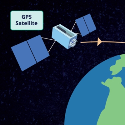
A remote 900 miles from Anchorage, AK, and deep in the treacherous Bering Sea sits the Okmok volcano. Okmok last erupted in 2008, sending ash into the sky and airspace used by thousands of civilian flights between North America and Asia. Okmok is one of many active volcanoes along what's known as the Aleutian Islands Arc. Given the Arc's activity and proximity to Alaska, Canada, and important transportation routes, scientists and officials are keenly interested in keeping a close eye on the volcanoes. But the Arc's isolated and dangerous location makes these volcanoes difficult to reach and monitor with typical ground-based global positioning system (GPS), seismic, and other equipment
To help close this technical divide, NASA created an online archive of satellite-based synthetic aperture radar (SAR) scans of active volcanic and earthquake areas around the world that can be used to quickly analyze and determine if and how these areas are changing or deforming. Deformation in a volcano is an indicator of magma movement or pressure changes that could lead to an eruption. For the first time, researchers in a newly published study have successfully used the new archive of SAR scans to systematically measure volcanic deformation across Okmok and other Aleutian volcanoes from 2015 to 2021. This study demonstrates the incredible speed and many benefits of using these analysis-ready data.
Volcanoes in the Cloud
The SAR image archive is called the Advanced Rapid Imaging and Analysis (ARIA) project’s Sentinel-1 Geocoded Unwrapped Interferogram (ARIA-S1-GUNW). The images are derived from data recorded by the ESA (European Space Agency) Sentinel-1 satellite. The archive is part of ARIA's Enabling Cloud-Based InSAR Science for an Exploding NASA InSAR Data Archive project, or colloquially InSAR in the Cloud. The overall work on this NASA-funded project is described in the 2023 Earthdata article, Big Data Meet Open Science.
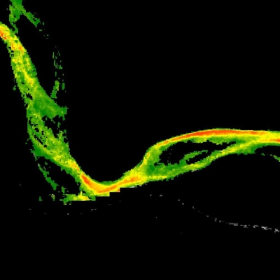
InSAR stands for interferometric SAR data, which are two SAR images acquired over the same location but at different times that are combined to create an interferogram. Researchers can look at interferograms to precisely measure elevation changes over time across volcanoes and other landforms.
InSAR files are incredibly large and require a lot of computing power to create and process. InSAR in the Cloud does all of the heavy lifting of producing analysis-ready interferograms and making them available through NASA's Distributed Active Archive Centers (DAACs). The project also supplies the DAACs and their users with the utilities for discovering, accessing, and cloud-processing the InSAR data.
InSAR in the Cloud is led by Principal Investigator Dr. David Bekaert at NASA's Jet Propulsion Laboratory (JPL) in Pasadena, CA.
"InSAR in the Cloud now has more than one million products and is one of the largest archives of InSAR products in the world," said Bekaert. "We take care of all the lower level data processing, allowing users to focus more on the science. For the Aleutian Islands study, we provided Level 2 processing of six years of Sentinel-1 satellite data of the area and delivered these data to the Alaska Satellite Facility DAAC (ASF DAAC) in just a matter of weeks."
Rates of Change

Once the data were available through NASA's ASF DAAC, a team led by Dr. Zhong Lu, an InSAR in the Cloud project team member at Southern Methodist University in Dallas, TX, began working with them. Lu is an expert in using radar and space-based data to study volcanoes. For the new study of Aleutian volcanoes, Lu guided his doctoral student and lead author Jiahui Wang in conducting the research. Wang conducted a time-series analysis of the island volcanoes to show their rate of inflation or deflation from 2015 to 2021. The researchers used both the interferograms and the analysis tools provided by InSAR in the Cloud to complete their work in far less time than it would take if they had to fully process these data on their local computers.
"In previous studies of the volcanoes from 1990 to 2010, we had to download data from the ASF DAAC and foreign space agencies and then process [the data] ourselves using our own computers," said Lu. "Using the previous approach, this new study could have taken a few years to complete. With InSAR in the Cloud, Jiahui completed the work in just five months."
When the analysis was complete, the study team found that more than 15 Aleutian volcanoes exhibited deformation from tectonic and magmatic processes, and changes were detected for the first time in the Tanaga, Great Sitkin, and Yunaska volcanoes. Okmok is a uniquely accessible and instrumented volcano, so they also used its GPS and other on-the-ground data to validate deformation measurements of the caldera calculated using the InSAR imagery.
"The fact that we were able to do the analysis so quickly and detect changes where we'd never seen them before has shown that InSAR in the Cloud really is the future of data processing to study the behavior of volcanoes for anticipating future eruptions," said Lu.
For the Public Good
In addition to NASA and academic researchers, InSAR in the Cloud data are valuable to the communities and agencies that deal directly with understanding and protecting people from volcanic eruptions. A key agency is the United States Geological Survey (USGS), which is charged with monitoring, analyzing, and predicting current and evolving Earth system interactions and delivering actionable information at scales and timeframes relevant to decision-makers.
"This study demonstrates the value in using powerful cloud-based computing in combination with the rapidly growing quantity of satellite SAR data to provide critical insights into volcanic and seismic activity," said Dr. Mike Poland, a USGS lead geophysicist. "Timely and comprehensive space-based monitoring like this is vital for improving forecasts of volcanic activity, especially in areas like the Aleutian Islands that, though remote, still pose hazards to nearby communities and air traffic."
With the success of InSAR in the Cloud, the development of free and open production of InSAR data products are going to the next level through the JPL-led Observational Products for End-Users from Remote Sensing Analysis (OPERA) project. OPERA will be producing an InSAR time-series Surface Displacement product suite over North America and U.S. Territories. The products will be derived from data acquired by both Sentinel-1 and the upcoming NASA-ISRO (Indian Space Research Organization) SAR (NISAR) mission. This higher level product suite will further reduce technical barriers to using these data and facilitate even more rapid analysis of Aleutian volcanoes.
As for InSAR in the Cloud and its interferograms, researchers and decision-makers wanting to understand and prepare for volcanic eruptions can start using them today. Bekaert, Lu, and the InSAR in the Cloud project team have created and successfully demonstrated an archive and tools that make it quicker and easier to analyze and track changes to volcanoes. In a sense, they’ve brought us much closer to understanding even the remotely located Okmok.