When a natural disaster or severe weather strikes, delivering actionable, decision-ready satellite data to federal agencies and first responders is critical. Unfortunately, this is often a complex process that requires a good deal of technological and data-processing know-how. This is especially true when the satellite data come from spaceborne radar instruments, which often require specialized skills and the use of advanced computing environments.
The Observational Products for End-Users from Remote Sensing Analysis (OPERA) project at NASA’s Jet Propulsion Laboratory (JPL) in Southern California is on a mission to change this by developing analysis-ready products to reduce the technical barriers to using satellite remote sensing observations.
The OPERA project team released analysis-ready Surface Water and Surface Disturbance products derived from Harmonized Landsat and Sentinel-2 (HLS) optical data in early-2023, and has now released two new analysis-ready radar products. The Radiometric Terrain Corrected (RTC) Synthetic Aperture Radar (SAR) backscatter and Coregistered Single-Look Complex (CSLC) products are derived from the C-band SAR instrument aboard the ESA (European Space Agency) Sentinel-1 satellites.
“The initial products released by OPERA [Surface Water and Surface Disturbance] were derived from optical satellite observations. As such, the mapping of water extent and vegetation disturbance can be at times hampered by the presence of thick clouds or a lack of sunlight illumination at night. Radar provides a complementing view to the optical satellites, in that it can penetrate through clouds and “see” in the dark, thus allowing for the retrieval of water, disturbance, displacement, and much more—24/7,” said Dr. David Bekaert, OPERA program manager.
The Radiometric Terrain Corrected SAR Backscatter Product
The RTC product is generated from Sentinel-1 SAR data (product shortname: RTC-S1). It is a 30-meter Level 2 GeoTIFF-formatted product projected on the Universal Transverse Mercator (UTM)/Polar stereographic map projection system. The 30-meter Copernicus Global Digital Elevation Model (DEM) is the reference DEM used to correct for the impacts of topography and geocode the product. The RTC-S1 data product has a near-global geographic coverage, which includes all landmasses excluding Antarctica.
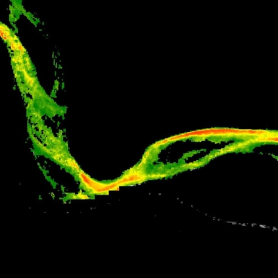
The radar signals stored in the product are largely related to the physical properties of the ground, including surface roughness, soil moisture, and vegetation conditions.
“Because of its direct connection with the ground surface physical properties, the [RTC-S1] product has many applications in resource management, scientific research, and hazard response. For example, RTC changes over time can be used to provide post-disaster assessment after landslides or track changes in water bodies such as rivers, lakes, or reservoirs,” said OPERA Project Scientist Dr. Steven Chan. The RTC-S1 is also the foundation of OPERA’s upcoming near-global OPERA Dynamic Surface Water Extent from Sentinel-1 (DSWx-S1) data product.

“We are very excited for the upcoming OPERA DSWx-S1 product, which is slated for forward stream production in 2024. This product will allow users to examine water extent at the global scale regardless of cloud-cover,” said Dr. Alexander Handwerger, OPERA deputy project scientist.
The Coregistered Single-Look Complex Product
The CSLC-S1 product is generated from Sentinel-1 SAR data (product shortname: CSLC-S1), and consists of Single-Look Complex (SLC) images that are precisely aligned or coregistered to the UTM/Polar stereographic map projection system. The geocoding and coregistration features are what make the OPERA CSLC-S1 an analysis-ready product, as they allow users to easily analyze a stack of radar images to detect changes on land surfaces. The CSLC-S1 data product has a geographical coverage over North America, which includes the United States and U.S. Territories, Canada within 200 km of the U.S. border, and all mainland countries from the southern U.S. border up to and including Panama.
The CSLC-S1 images contain both amplitude and phase information of the complex radar return. The amplitude is primarily determined by ground surface properties (e.g., terrain slope, surface roughness, and physical properties), and phase primarily represents the distance between the radar and ground targets. The Level 2 CSLC-S1 product is provided in the Hierarchical Data Format Version 5 (HDF5) and will be posted at 5x10-meter spacing in east and north direction, respectively. The CSLC-S1 product also serves as the foundation for the OPERA Surface Displacement Product, which will be released in late 2024.

“Before OPERA’s CSLC-S1 product, a substantial amount of data processing was needed to create analysis-ready SAR data,” said Handwerger. “Now, with OPERA’s CSLC-S1 product release, we have significantly lowered the technical barrier, which widens the user base and allows more people to use SAR data in their research and applications.”
Chan notes that this is a data product the user community has long been waiting for. “Users within the radar remote sensing community have long desired access to more analysis-ready radar observations. Most radar data products to date require users to either know how to pre-process the data before they can be used for a given application or to have fully processed data that can only be used for a small range of applications,” he said. “Those who want to explore alternate uses of the data, find new applications, and make new discoveries must first overcome the challenge of learning how to pre-process these complex data.”
OPERA’s RTC-S1 and CSLC-S1 products meet this need by providing users with cloud-friendly, analysis-ready data that they can then use on their own or as inputs in the development of new and unique applications or to refine existing applications.
“We’re very excited about the release of our RTC-S1 and CSLC-S1 data products, as they usher in a new era of data accessibility and expanded applications that go beyond radar data specialists,” said Bekaert. “Advanced applications are becoming accessible to our federal stakeholders, and we’re thrilled to help meet their needs for radar satellite observations.”
The OPERA project is managed by NASA's JPL, with partners from NASA’s Goddard Space Flight Center, the U.S. Geological Survey (USGS), the University of Maryland College Park, the University of Alaska Fairbanks, and Southern Methodist University. OPERA data products are developed in collaboration with the Satellite Needs Working Group, a US Group on Earth Observations (USGEO) effort to identify, communicate, and address Earth observation needs of federal agencies by leveraging data from current and upcoming satellite assets.
Data Access
OPERA’s RTC-S1 and CSLC-S1 products can be downloaded from NASA’s Earthdata Search and NASA's Alaska Satellite Facility Distributed Active Archive Center (ASF DAAC) located in the Geophysical Institute at the University of Alaska Fairbanks. ASF DAAC acquires, processes, archives, and distributes SAR data from polar-orbiting satellite and airborne sensors to advance Earth science research. Most of the datasets at ASF DAAC, including Copernicus Sentinel-1, are open access and freely available to the public for download. To access OPERA data at ASF DAAC, visit the OPERA page on the ASF DAAC website and then click on the Data Discovery tab.