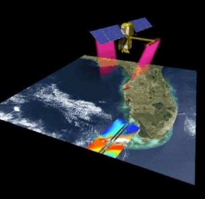
NASA's Surface Water and Ocean Topography (SWOT) satellite mission is an endeavor of firsts. It is the first mission to provide a comprehensive inventory of Earth's freshwater resources from space; it is the first satellite altimetry mission to provide approximately one terabyte of data each day; and it is the first satellite to carry a Ka-band Radar Interferometer (KaRIn), a new instrument designed to capture precise measurements of the height of both the ocean and freshwater bodies (i.e., lakes, reservoirs, and rivers).
As its name implies, KaRIn is a radar instrument that uses the Ka-band frequency at the microwave end of the electromagnetic spectrum to penetrate cloud cover and the dark of night. As a result, it can take measurements regardless of weather or time of day. The instrument configuration consists of an antenna at both ends of a 33 foot (10 meter) boom that can see the surface of water in the way other altimeters can’t.
Yet, while being the first of something is notable, it can also present challenges. Such was the case with KaRIn during SWOT's calibration phase. Calibration and validation, a customary stop on a satellite's journey from launch to normal operations, enlists a number of procedures designed to ensure the validity of remotely sensed data from the instruments aboard a spacecraft. For instruments similar to their predecessors, the procedures and infrastructure required for calibration and validation may be well established. For new instruments like KaRIn, calibration and validation often require a novel approach.
In the following interview, Dr. Shailen Desai, NASA's Measurement System Engineer for SWOT, discusses the challenges and concerns associated with the calibration and validation of KaRIn, as well as how SWOT differs from previous altimetry missions and the benefits of releasing SWOT’s calibration and validation data to the user community.
Can you provide a brief overview of the SWOT mission and its significance, particularly in regard to how it differs from previous altimetry missions?
The SWOT mission is a partnership between the hydrology and oceanography communities and its primary objectives are to provide a global survey of surface water over land and the ocean with unprecedented spatial resolution. It endeavors to answer the questions, Where is our surface water? What is the height of the water? And how is that [height] changing with time through the life of SWOT?
Traditional altimetry missions, such as the Jason series or Copernicus Sentinel-6 Michael Freilich, primarily target the ocean. Those missions can also observe the height of inland water bodies, but only for larger water bodies and only beneath their respective satellite ground tracks.

What's new with SWOT is the novel Ka-Band Radar Interferometer that we often refer to as KaRIn. This new instrument provides measurements of water service elevation across a 120 kilometer (km) swath with significantly finer spatial resolution than the traditional nadir altimeters. One could think of it as a carpet 120 km-wide with a 20 km gap in the middle of it. The onboard nadir altimeter adds to that by providing point measurements in the middle of that gap, along the satellite ground track. So, the traditional altimetry missions only provide point measurements along the ground track whereas SWOT provides measurements spanning 120 km and with significantly better spatial resolution.
In addition to KaRIn, SWOT includes the traditional ocean altimetry suite of instruments, including a nadir altimeter like we have on Jason, a microwave radiometer, which measures the amount of water vapor between SWOT and Earth's surface, and tracking systems that enable accurate determination of the position of the satellite.
I want to ask about the calibration and validation phase for SWOT, but before I do, I’d like to discuss the calibration and validation of satellite instruments in general. What are the goals of calibration and validation?
Calibration and validation exercises are performed on each of the satellite's instruments. Further, calibration and validation happen through the life of a satellite mission.
Most, if not all, instruments require calibration to achieve and maintain measurement accuracy. Most often, this means determining the parameters that are applied during ground processing of the raw instrument data to provide accurate measurements for scientific use. Many of these calibrations are defined pre-launch as best as we can; however, this isn't always possible, mainly due to our inability to accurately represent the space environment. Some calibration parameters can change over time due to environmental effects, such as instrument temperature, as well as instrument aging.

Validation aims to provide us with the confidence that the measurements received after calibration are trustworthy, so we can have confidence in the resulting science or applications. The validation allows us to confirm that the calibrations are reliable and determine the accuracy of the resulting measurements from all of the instruments.
So, the reason calibration and validation are often linked together is because those activities are related, with one set of activities affecting the other.
Is there a standard or customary approach for conducting calibration and validation exercises—for example, comparing the measurements from instruments aboard a recently launched satellite with those from more mature sensors on other satellite missions, airborne campaigns, or ground networks—or are they developed specifically for each mission?
I don't know if this is always the approach, but from what you described it's generally similar. Calibration and validation involve using the in-flight measurements on their own, as well as comparing those in-flight measurements to measurements from other satellites or from measurements obtained from sensors on the ground or in the field.
The traditional altimetry missions have benefitted from almost three decades of heritage calibration and validation exercises, so in that sense, the concepts and methods for calibration and validation of those traditional altimeters are very well understood and the required infrastructure on the ground is mature and extensive. As experience grows with those altimeters and as technology advances, newer calibration and validation methods are often introduced. In the case of SWOT, because this new instrument—KaRIn—had never been flown in space, we really needed new calibration and validation activities.
How did SWOT's calibration phase differ from those of previous altimetry missions?
We needed to develop new methods, as the calibration and validation of SWOT's KaRIn instrument is particularly challenging for multiple reasons. For example, the size of the instrument itself and the measurement concept of that instrument made it especially difficult to completely calibrate pre-launch. So, we deferred determination of some of the calibration parameters until after launch out of necessity. Second, because KaRIn has no heritage, we had to plan on developing new methods to validate its measurements. And then third, KaRIn provides measurements across a 120 km [wide] swath, so the calibration and validation exercises had to be applied across the swath rather than at point-wise measurements along the satellite ground track.
So, yes, our SWOT field campaigns are different in terms of methodology for validation. Our field campaigns included the use of both airborne and field measurements, as well as comparison to measurements from other satellites. We had to develop novel methods to validate the significantly higher spatial resolution of the KaRIn measurements as compared to the nadir altimeters, as well as methods to validate across the swath instead of point measurements along the ground track. We developed comprehensive field campaigns for the ocean, rivers, and lakes.
For example, in one case we had an ocean campaign where we had a string of instruments along the ground track, which were spaced very close to each other. The goal there was to determine if KaRIn can provide measurements of the ocean at the expected spatial resolution. An airborne lidar was also flown over the same site both along and across the swath to validate the KaRIn measurements. On the hydrology side, we have campaigns of various rivers and lakes. We had boats towing GPS [Global Positioning System] buoys or instruments along the river that measured their height. We did similar exercises in lakes as well.

SWOT is quite novel in having the capability to measure inland water bodies and rivers, so developing new methods or leveraging existing methods, and searching for methodologies to provide measurements that we could compare to those from SWOT was quite useful.
What were the results of SWOT's calibration and validation exercises? I assume the results were positive because SWOT is in orbit and SWOT data products have already been released.
Having SWOT in orbit and sending back data only says the instruments are on and they're working. The objective of calibration and validation is to say how well they are working.
SWOT's calibration and validation exercises are ongoing, and we expect them to continue through the life of the mission, but where we are today is that all of the instruments are now well-calibrated. We do expect those calibrations will be more finely tuned as we receive more in-flight data and as we continue to compare them to measurements in the field.
The validation results suggest that the requirements for SWOT's oceanography measurements are being met. The validation of inland water bodies is ongoing, but I would say the offline results suggest that those measurements will also meet their requirements. Some of the most significant remaining challenges lie in maturing ground processing for the inland water bodies. So, for the hydrology science data products, the validation exercises are especially useful in the feedback loop and informing how we process the data.

Can you elaborate on that?
When we do the comparisons between the field measurements and the science data products coming out of KaRIn, we might find that the processing approach of those measurements is deficient in some way. The complexity here is that measurements of surface water may be impacted by small water bodies nearby or, for example, there may be a wet field near a river, so we have to make sure we are we are accounting for those sorts of effects. This is what we call the phenomenology of the measurement, meaning, what kind of phenomenon might be near the water bodies of interest that can impact the way we process the data. So, we have to take some care in these instances.
As I mentioned, we noticed wet fields were impacting how rivers were represented. Sometimes you could have effects from so-called bright targets near water bodies, or even from the ways different water bodies connect to one other. We often think of rivers as a single body of water, but sometimes you can have a river that has sandbars or other land features inside it. We have to be careful about these, too. Generally, the complexity of the size and shape or rivers and lakes make it challenging to validate SWOT's measurements for every case.
Are the calibration and validation exercises that take place later on in the mission the same as those conducted at the beginning of the mission, or do they evolve?
Yes, they will most certainly evolve. We are planning to use many of the same approaches we've used thus far, those used in the campaigns for rivers and lakes, for example, and we plan to conduct many more of those throughout the life of the mission. However, the results from those methods could inform how we might change some of the approaches we use in the field.
The SWOT calibration and validation data are available to the user community via NASA's Physical Oceanography Distributed Active Archive Center (PO.DAAC). Why were these data made available and what use are they to the user community?
The volume of data coming back from SWOT is so large—it spans so many rivers, so many lakes, and the global ocean—and it is quite challenging to validate SWOT's measurements of all these different areas. But, given that we developed novel techniques for SWOT's calibration and validation, we felt that the project and the user community itself would benefit from giving access to these data to as many people as possible.
Having others look at the data from our field campaigns, doing their own comparisons with the SWOT science data products, and then potentially providing us feedback might help us improve the products so that we can continually evolve the quality of the science data products over time. In addition, our decision to release these data also supports NASA's open data policy. We have data that we are collecting in the field, and we thought it was just as important to make these data available to users as the SWOT inflight measurements.