Filter By
Submit an abstract to the Leveraging Unsupervised Learning Techniques in Earth Science Observations session, which will take place at the American Geophysical Union Fall Meeting.
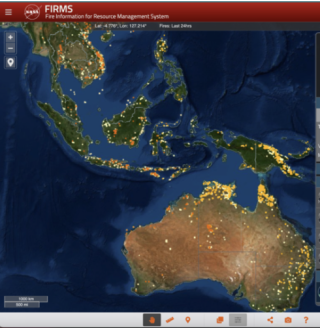
Learn how to change the colors of the fires/thermal anomalies, change the fire pixel size, show only day or night detections, and color code fires by fire radiative power, confidence, or time since detection.
At the American Geophysical Union Fall Meeting, IMPACT will lead two sessions aimed at bringing greater awareness and discussion of airborne and field data issues and solutions.
Submit your abstract for our Fall 2022 American Geophysical Union artificial intelligence sessions.
Submit your abstract to our sessions on informatics at the American Geophysical Union Annual Meeting.
FIRMS fire map users now have the option of capturing a map view as a GeoTIFF image file.
FIRMS recently integrated ultra real-time MODIS and VIIRS active fire data from multiple direct readout ground stations in the continental United States.
Meet two members of IMPACT’s Airborne Data Management Group.
IMPACT was instrumental to a recent enhancement of NASA’s Fire Information for Resource Management System.
Through the Commercial Smallsat Data Acquisition (CSDA) Program, NASA is making substantial amounts of privately-acquired data available to researchers.