Dr. Margaret “Maggi” Glasscoe, Research Associate, University of Alabama–Huntsville and Disasters Coordinator for NASA’s Applied Sciences Disasters Program
Research Interests: Studying earthquakes, floods, and other natural hazards to both understand these phenomena and deliver scientific results to decision-makers to help them assess the risk of and prepare for natural disasters; facilitating the delivery of NASA data and products to decision-makers and federal agencies to aid disaster response
Research Highlights: According to The Human Cost of Disasters 2000–2019, a 2020 report from the United Nations (UN) Office for Disaster Risk Reduction, there were roughly 7,348 major disasters from 2000 to 2019 that claimed 1.23 million lives, affected 4.2 billion people, and resulted in approximately $2.97 trillion (USD) in global economic losses. These statistics indicate a “sharp increase” in the number of disasters from the previous 20 years, say the report’s authors, with more than double the number of major floods (from 1,389 to 3,254) and higher incidences of droughts, wildfires, extreme temperature events, and geophysical events, including earthquakes and tsunamis.
The report’s authors tie the increase in these hazards to the rise in climate-related disasters, which is a significant statement, as it suggests the ongoing effects of climate change will likely increase the frequency of these events in years to come. As Mami Mizutori, the UN Secretary-General’s Special Representative for Disaster Risk Reduction, said following the release of the report, “Disaster management agencies, civil protection departments, fire brigades, public health authorities, the Red Cross and Red Crescent, and many NGOs are fighting an uphill battle against an ever-rising tide of extreme weather events. More lives are being saved but more people are being affected by the expanding climate emergency. Disaster risk is becoming systemic with one event overlapping and influencing another in ways that are testing our resilience to the limit.”
For years, NASA, in collaboration with its federal agency and international partners, has used data from Earth-observing satellites in the on-going efforts to improve the scientific community’s understanding of the phenomena that cause natural hazards, assess community exposure and vulnerability to hazardous events, and inform early warning systems and support disaster mitigation and response efforts. Among the scientists involved in this work is Dr. Margaret “Maggi” Glasscoe, research associate at the University of Alabama–Huntsville and disasters coordinator for NASA’s Applied Sciences Disasters Program, which uses Earth-observing data and applied research to improve the prediction of, preparation for, response to, and recovery from hazards and disasters around the world.
“I study the processes of earthquakes using computer simulations and Earth observations to try to better understand fault interactions and how the surface of the Earth moves during and after earthquakes,” said Glasscoe. “My earthquake research helps us understand the fundamental processes of fault interactions and how the surface and near-surface of the Earth move during and after earthquakes. This may not only shed light on how faults move and change the landscape, but also improve our understanding of the hazards they pose.”

Glasscoe also conducts applied research on flooding and is developing an assessment and notification tool to help at-risk communities around the globe make better flood-response decisions.
“The flood assessment and alerting tool allows us a unique opportunity to provide global information, which so far is unavailable on a reliable basis,” Glasscoe said. “In the U.S., we have very good coverage provided by NOAA through the National Weather Service regarding flood risk; however, globally, there is a definite lack of reliable information on the severity and extent of flooding. The methodology and alerts we are developing would allow users of DisasterAWARE®, a multi-hazard decision-making platform created by the Pacific Disaster Center, to receive reliable flooding alerts and make informed decisions during response.”
Yet, regardless of what type of hazard she’s focused on, NASA Earth science data are critical components of her work.
“I use modeling software developed at NASA’s Jet Propulsion Laboratory to conduct my earthquake research and Global Navigation Satellite System and Synthetic Aperture Radar (SAR) to validate the models,” Glasscoe said. “For my flooding projects, we capitalize on NASA-developed technology to deliver flood risk severity alerts and inundation and damage assessments to our end user, the Pacific Disaster Center, for world-wide dissemination through DisasterAWARE.”

Glasscoe and her colleagues discuss the methodology they are developing to deliver those flood risk severity alerts and damage assessments in the 2021 paper “Integrating Hydrologic Models and Earth Observation Data for Global Flood Forecasting and Alerting in Near Real-Time.” Their method, a model of models approach, leverages outputs from two models—the European Commission’s Copernicus Emergency Management Service’s Global Flood Awareness System (GloFAS) and the University of Maryland’s NASA-funded Global Flood Monitoring System (GFMS)—and then uses a variety of satellite data to ground-truth the model results and delineate flooded areas to generate classifications of flood severity. The flood severity classifications (denoted as a risk score), along with estimates of potential impacts derived from optical imagery, are then disseminated as alerts via DisasterAWARE to its millions of users worldwide. These alerts allow the end users to better assess flood risk, implement the necessary preparatory actions (e.g., issuing evacuation notices), or expedite disaster response activities.
According to Glasscoe and her co-authors, this approach to delivering flood risk severity alerts and damage assessments is an improvement to current flood-risk assessment practices.
“The availability of different flood outputs poses a challenge for stakeholders to decide the best model to use that has highest accuracy,” Glasscoe and the coauthors write. “Our proposed model eliminates this challenge as it forecasts flood severity (i.e., risk score) by integrating accepted and globally available models and datasets.”
It also provides daily flood severity scores, which can be used by stakeholders to track the change in flood severity over time and identify high-risk areas requiring resources and immediate attention.
“This information is especially crucial for smaller communities with limited sources as can be seen in Africa,” Glasscoe says.
To validate the flood model outputs and accuracy of the flood severity scores, Glasscoe and her colleagues use SAR data from the European Space Agency’s Sentinel-1 satellite, along with near-real time (NRT) data, or data that are made available quicker than routine processing allows, from the Moderate Resolution Imaging Spectroradiometer (MODIS) aboard NASA’s Aqua and Terra satellites, and the Visible Infrared Imaging Radiometer Suite (VIIRS) instruments aboard the joint NASA/NOAA Suomi National Polar-orbiting Partnership (Suomi NPP) and NOAA-20 satellites.

This NRT MODIS and VIIRS data are distributed by NASA’s Land, Atmosphere Near real-time Capability for EOS (LANCE). LANCE supports users like Glasscoe who are interested in monitoring a wide variety of natural disasters and other natural and human-made phenomena by providing NRT data within three hours from satellite observation and imagery within three to five hours after observation.
“The LANCE data is important because it allows us to create routine, NRT flood severity estimates that are validated by NASA Earth observation data,” said Glasscoe, who is a member of the LANCE User Working Group (UWG). In this capacity, Glasscoe offers input to stakeholders on a broad range of topics related to the LANCE system’s capabilities and services.
Data and imagery from LANCE are also an important component of Glasscoe’s work with NASA Applied Science Disasters program.
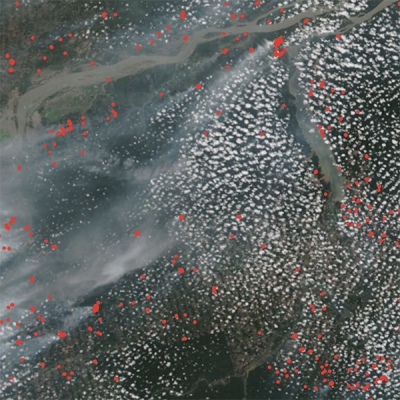
Perhaps the clearest indication of how the Disaster’s Program benefits from LANCE data, can be seen on the program’s website, which features applications including NASA Worldview, which allows users to interactively browse more than 1,000 global, full-resolution satellite imagery layers (many of which are updated within three hours of observation) and download the underlying data, and the Disasters Mapping Portal, an Esri-based online interface for viewing, analyzing, and downloading the latest near real-time and disaster-specific data products in Geographic Information Systems (GIS) format. The portal offers more than a dozen NRT data products, including the Black Marble Nighttime Lights Blue/Yellow Composite product, which combines day-night band imagery and infrared data to enhance first responders’ ability to determine whether changes in nighttime lights are the result of power outages or dense cloud cover, and the NRT MODIS 1 day, 2 day, or 3 day Global Flood Maps, which allow users to see where potential flood water (shown in red) has been detected across the world.

In addition to these online offerings, Disaster Coordinators like Glasscoe continuously monitor world news and communicate with international programs to identify hazards that may threaten life and property in communities around the globe. When a potential disaster is identified, coordinators get together with their colleagues in NASA and across the broader research community to determine the most appropriate Earth-observing resources to support risk reduction and response efforts in the locality impacted by the event. Then, after need and capability are identified, the team works directly with local stakeholders to establish a flow of information between NASA subject-matter experts and local response agencies to help them make real-time decisions that can save lives and mitigate impact. When hazards occur within the U.S., the Disasters program regularly works with FEMA, the USGS, and state and local governments to quickly deliver critical data and analysis.
Undoubtedly, NRT data and imagery from LANCE is a vital tool for Disaster coordinators to use in expediting that data delivery, and if the number of hazardous events continues to rise as the impacts of climate change continue, then LANCE’s ongoing efforts to support the monitoring of natural hazards and other phenomena are destined to become even more essential for alerting at-risk communities, assessing hazard-caused damage, and coordinating hazard response.
Representative Data Products Used or Created:
Available through LANCE:
- Atmospheric Infrared Sounder (AIRS) via NASA LANCE
/earth-observation-data/near-real-time/download-nrt-data/airs-nrt - Moderate Resolution Imaging Spectroradiometer (MODIS) via NASA LANCE
/earth-observation-data/near-real-time/download-nrt-data/modis-nrt - Visible Infrared Imaging Radiometer Suite (VIIRS) via NASA LANCE
/earth-observation-data/near-real-time/download-nrt-data/viirs-nrt
Other data products used:
- Advanced Spaceborne Thermal Emission and Reflection Radiometer (Terra ASTER), NASA
https://terra.nasa.gov/data/aster-data - Global Flood Awareness System (GloFAS), European Commission’s Copernicus Emergency Management Service
https://www.globalfloods.eu/ - Global Flood Monitoring System (GFMS), University of Maryland
http://flood.umd.edu/ - Hurricane Weather Research and Forecast System (HWRF) Model
https://www.emc.ncep.noaa.gov/gc_wmb/vxt/HWRF/index.php - Global Web-Enabled Landsat Data Monthly (GWELDMO)
doi:10.5067/MEaSUREs/GWELD/GWELDMO.031 - Synthetic Aperture Radar Sensor, European Space Agency Sentinel-1 satellite
https://asf.alaska.edu/data-sets/sar-data-sets/sentinel-1/ - Uninhabited Aerial Vehicle Synthetic Aperture Radar (UAVSAR), NASA, JPL
https://uavsar.jpl.nasa.gov/
Read about the Research:
Donnellan, A., Parker, J., Heflin, M., et al. (2021). Improving access to geodetic imaging crustal deformation data using GeoGateway. Earth Science Informatics (2021). doi:10.1007/s12145-020-00561-7
Glasscoe, M., et al. (2021). Integrating Hydrologic Models and Earth Observation Data for Global Flood Forecasting and Alerting in Near Real-Time. 2021 IEEE International Geoscience and Remote Sensing Symposium IGARSS, pp. 554-557. doi:10.1109/IGARSS47720.2021.9554638
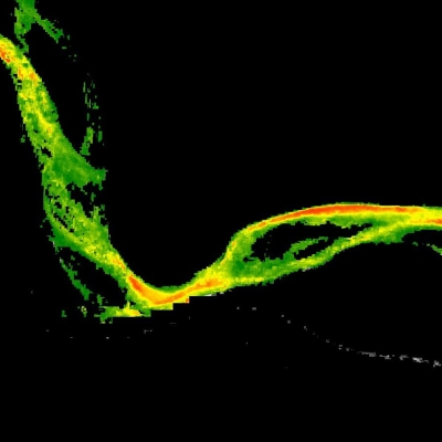
Parker, J., Donnellan, A., & Glasscoe, M. (2021). Survey of Transverse Range fire scars in 10 years of UAVSAR Polarimety. Earth and Space Science, 8(5), e2021EA001644. doi:10.1029/2021EA001644